1. Market Analysis
Demand analysis for all development components.
Housing Market
| Metro Households | 61,290 |
| Median Household Income | $55,336 |
| Median Home Value | $153,600 |
| Median Age | 36.8 |
Source: Census ACS 2023
| Purchase Price | Est. PITI | Income Needed | Households Who Qualify |
|---|---|---|---|
| $140,000 | ~$1,080/mo | $43,200/yr | ~28,500 (47%) |
| $160,000 | ~$1,230/mo | $49,200/yr | ~25,400 (41%) |
| $180,000 | ~$1,380/mo | $55,200/yr | ~20,600 (34%) |
| $200,000 | ~$1,530/mo | $61,200/yr | ~16,500 (27%) |
| $250,000 | ~$1,905/mo | $76,200/yr | ~10,200 (17%) |
PITI estimates: 7% rate, 30-year term, FHA with PMI, taxes 0.76%, insurance $1,200/yr.
| Price Point | Qualified Households | % of Metro |
|---|---|---|
| $140,000 | ~28,500 | 47% |
| $160,000 | ~25,400 | 41% |
| $180,000 | ~20,600 | 34% |
| $200,000 | ~16,500 | 27% |
| $250,000 | ~10,200 | 17% |
At any price point between $140K-$250K, qualified buyer pool ranges from 10,000 to 28,000 households.
| Forrest Health System | 547-bed flagship, 7 hospitals, 19-county service area |
| University of Southern Miss | 13,170 students, major employer |
| Camp Shelby | 2,200 employees, 60,000 annual visitors |
| William Carey University | ~5,140 students |
| Hattiesburg Clinic | Multi-specialty physician group |
Marina Market
| Total Blueway Miles | 52.3 miles (Leaf + Bouie rivers) |
| Phase 1 (2018) | 10.8 miles — Eastabuchie to Chain Park |
| Phases 2-5 (2021) | 41.5-mile extension to Perry County |
| Partners | Piney Woods Conservation Group, Visit Hattiesburg, City |
"The waterways of Hattiesburg have been some of the most underutilized resources in our city, but that will not be the case going forward." — Mayor Toby Barker
| Sims Road Boat Ramp (Nov 2025) | $1M+ investment |
| MS Outdoor Stewardship Fund | $480,000 grant |
| 1% Parks & Recreation Tax | Remainder of funding |
| Features | ADA accessible, kayak rollers, winding pathway |
Hattiesburg is investing in river access infrastructure. The city has designated the Leaf River as a priority for outdoor recreation development.
| Public Boat Ramps | Chain Park, Sims Road, Eastabuchie, Pep's Point |
| Kayak/Canoe Activity | Growing — blueway signage, mile markers installed |
| Fishing | Bass, catfish, bream — active recreational fishery |
| Marina Slips in Hattiesburg | None |
| Covered Boat Storage | None at river |
| Commercial Services at Ramps | None |
Commercial Market
| Nearest River Restaurant | None on Leaf River in Hattiesburg |
| Nearest Bait Shop | Highway locations, not riverfront |
| Annual Visitors to Hattiesburg | ~3 million |
| Daily Visitor Spending | ~$2 million/day |
| Recreation Sector Growth | Fastest growing tourism sector (2024) |
| 5-Year Tourism Growth | 39% |
| 2024 Visitor Spending | $604 million (+3.7%) |
| State Ranking | 3rd most visited city in Mississippi |
| Key Attractions | Hattiesburg Zoo, Longleaf Trace, Paul B. Johnson State Park |
"Recreation grew the most in 2024... outdoor recreational opportunities continue to expand here in Hattiesburg." — Visit Hattiesburg
| Riverfront Restaurants (Leaf River) | None |
| Bait Shops at Boat Ramps | None — highway locations only |
| Convenience at Launch Points | None |
| Public Restrooms at Ramps | Limited |
Boaters and paddlers currently have no food, bait, or services at Leaf River launch points.
Recreation Market
| U.S. Glamping Market Growth | 12.8% CAGR (2025-2030) |
| Primary Demographics | Millennials, Gen Z, eco-conscious travelers |
| Average Nightly Rate (MS) | $75 (range $45-$150+) |
| MS Glamping Options | Growing — cabins, domes, safari tents, containers |
Glamping combines nature access with luxury amenities. Elevated platforms on floodplain land could offer unique riverfront glamping without permanent structures in the floodway.
| Use Cases | Weddings, reunions, corporate retreats |
| Differentiator | Riverfront setting, proximity to downtown |
| Season | Year-round (mild MS climate) |
| Comparable | Riverfront venues command premium pricing |
| Activity | Typical Market Rate |
|---|---|
| Kayak Rental (single) | $25-50/half day |
| Kayak Rental (tandem) | $40-70/half day |
| Guided Paddle Tour | $50-100/person |
| Glamping (MS average) | $75/night (range $45-150) |
| Event Venue (riverfront) | Premium over inland venues |
| Day-Use Fishing Access | $5-15/day typical |
Marina Townhome Market
| MS Waterfront Median (Gulf Coast) | $324,000 |
| MS Waterfront Average (statewide) | $472,536 |
| Riverfront Premium | Typically 15-30% over comparable inland |
| Hattiesburg Context | No existing riverfront townhomes for comparison |
| Gulf Coast Waterfront Median | $324,000 |
| MS Waterfront Average | $472,536 |
| Hattiesburg Riverfront Townhomes | None currently exist |
| Riverfront Premium (typical) | 15-30% over comparable inland |
No direct comparable exists in Hattiesburg. Gulf Coast and statewide data provide reference points for waterfront premiums.
Summary
| Segment | Current Supply | Demand Indicator |
|---|---|---|
| Starter Homes ($140-200K) | Limited new construction | 25,000+ qualified households |
| Waterfront Townhomes | None in Hattiesburg | Gulf Coast median $324K |
| Riverfront Restaurant | None on Leaf River | $604M visitor spending |
| Marina/Boat Slips | None in Hattiesburg | 52.3 miles of Blueway traffic |
| Riverfront Glamping | None on Leaf River | 12.8% CAGR national growth |
| Housing | |
| Qualified pool ($140-200K) | 16,500 - 28,500 households |
| Median home value | $153,600 |
| New construction gap | Limited inventory at entry price points |
| Marina/Commercial | |
| Annual visitors | 3 million |
| Blueway users | Growing (52.3 miles of paddling trail) |
| Riverfront competition | None |
| Recreation/Tourism | |
| Tourism growth | 39% over 5 years |
| Recreation sector | Fastest growing (2024) |
| City investment | $1M+ in Sims Road ramp alone |
Sources: Census ACS 2023, Visit Hattiesburg 2024 Tourism Report, WDAM, Hub City Spokes
2. Property
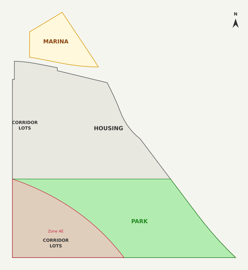
Three adjacent parcels on River Avenue.
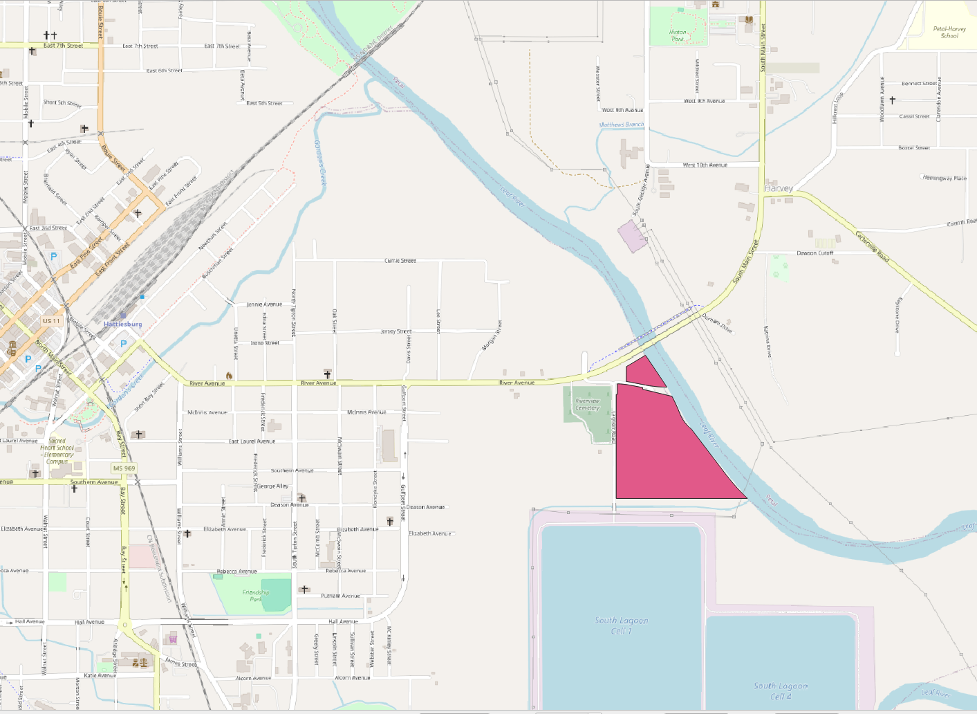
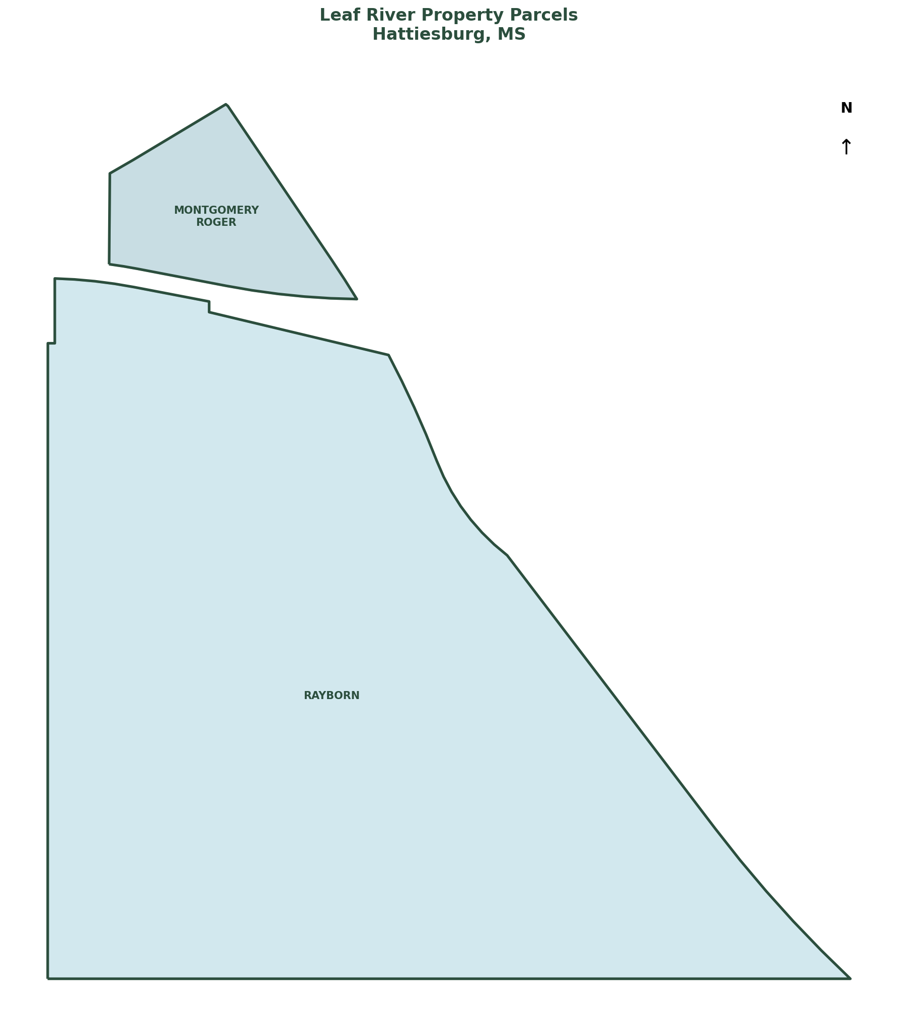
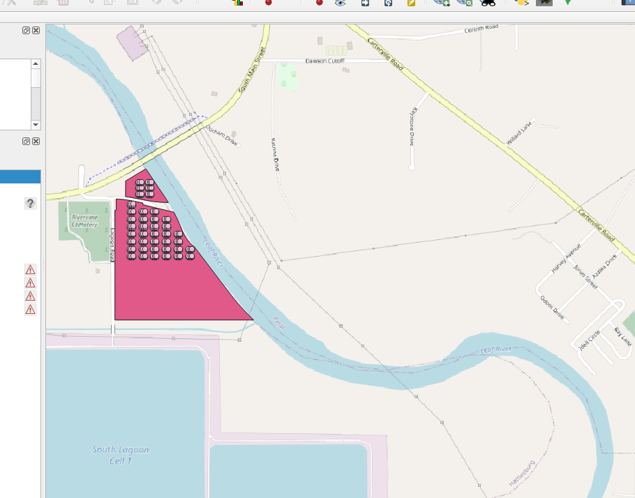
East Hattiesburg, Mississippi. Three parcels totaling ~31 acres on the Leaf River, just north of the city's sanitary lagoons. River frontage on the east, Lagoon Road on the west.
| PPIN | Owner | Acres | Zoning |
|---|---|---|---|
| 26700 | Montgomery Roger | 2.28 | A-1 |
| 26786 | Rayborn Ricky | 28.88 | A-1 |
| 26793 | Forrest County | TBD | A-1 |
Total private acreage: ~31 acres. County parcel sits between the two private parcels.
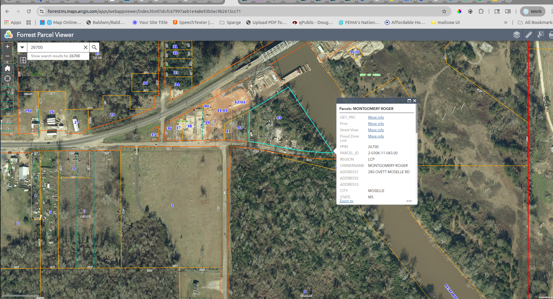
| Owner | Montgomery Roger |
| Property Address | 1916 River Avenue |
| Owner Address | 280 Ovett Moselle Rd, Moselle MS |
| Parcel ID | 2-030K-11-043.00 |
| Lot Size | 253' x 390' (~2.28 acres) |
| Assessed Value | $2,960 |
| Land Use Class | 1110 One Family Unit / 1410 Mobile Homes |
| Zoning | A-1 (Agricultural) |
Legal: BEG 146FT W SE COR SW1/4 NE1/4, N 382FT TO W LN LEAF RIVER SE ALG SD LN TO S LN SE1/4 NE1/4, W 341FT TO BG LESS PT TO FORREST COUNTY
Location: Block 011, Section 11, Township 04N, Range 13W
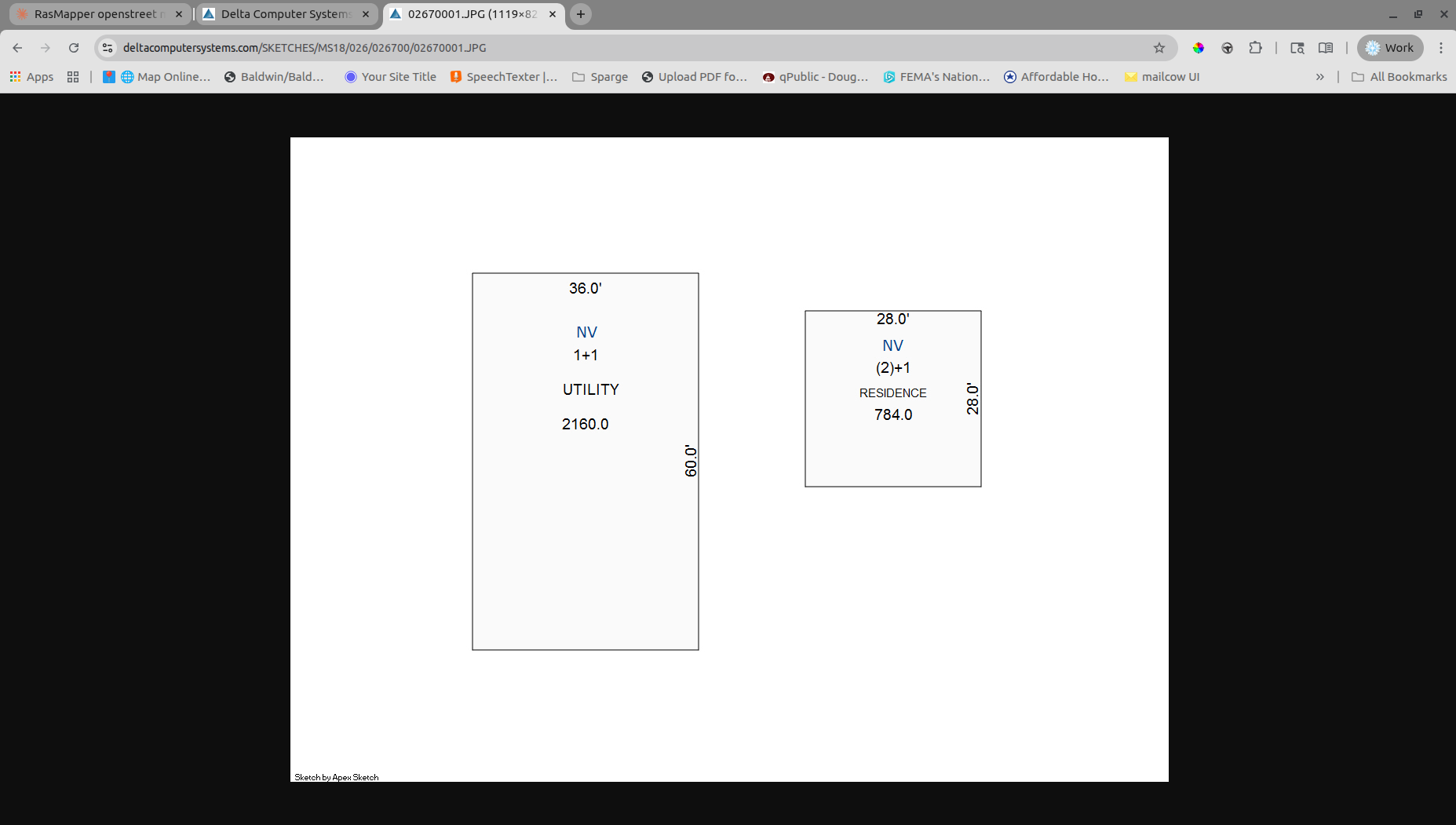
Site Features: Two existing concrete slabs from razed buildings. River frontage at north tip.
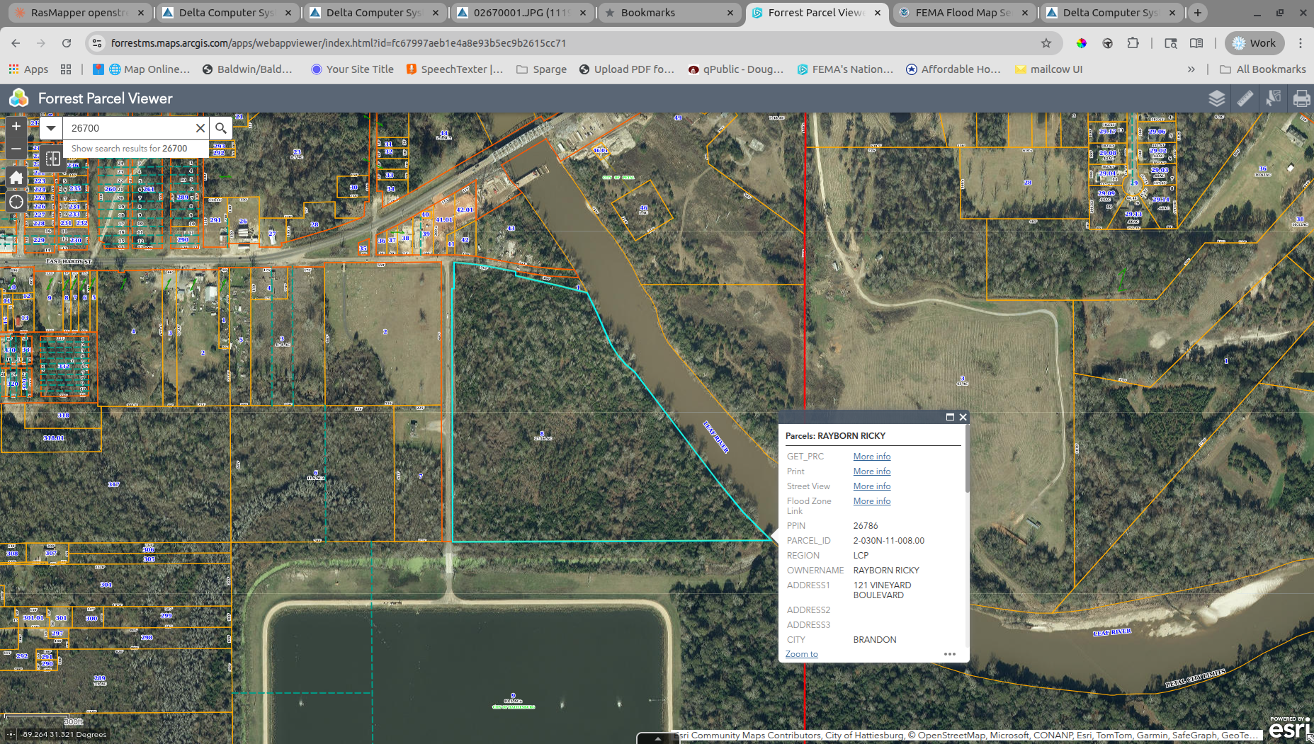
| Owner | Rayborn Ricky |
| Owner Address | 121 Vineyard Boulevard, Brandon MS |
| Parcel ID | 2-030N-11-008.00 |
| Acreage | ~28.88 acres |
| Zoning | A-1 (Agricultural) |
Location: Large waterfront parcel south of Montgomery parcel.
Site Features: Leaf River frontage on east. Lagoon Road on west edge.
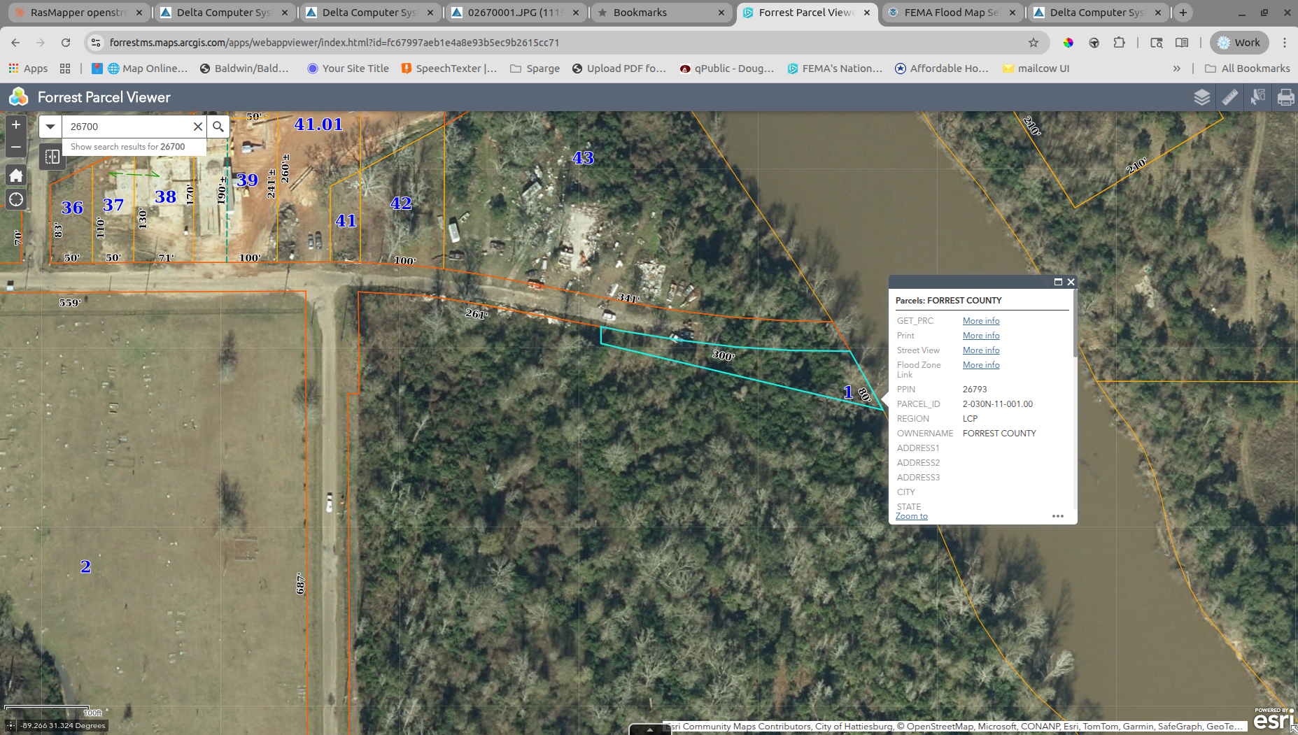
| Owner | Forrest County |
| Parcel ID | 2-030N-11-001.00 |
| Zoning | A-1 (Agricultural) |
| Position | Between the two private parcels |
County parcel shown in cyan.
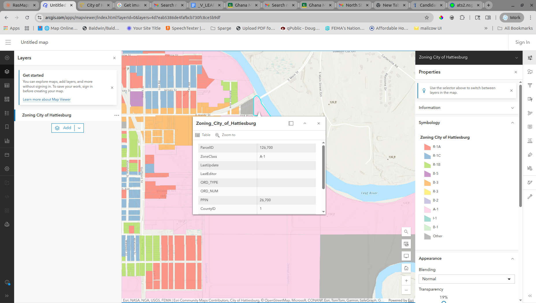
All three parcels zoned A-1 (shown in pink on City of Hattiesburg zoning map).
| A-1 Permitted Uses | Single-family, mobile homes, agricultural, accessory structures |
| Jurisdiction | City of Hattiesburg |
| East | River Avenue (property address) |
| West | Lagoon Road — north-south service road along western edge |
| South | Adjacent to sanitary lagoons |
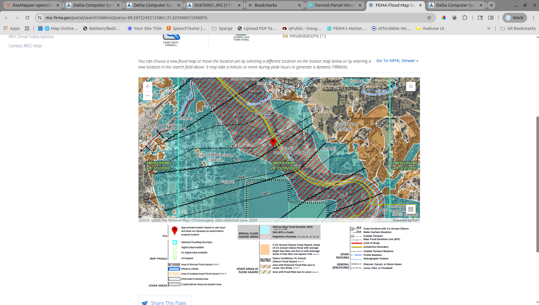
| PPIN 26700 | Floodway |
| PPIN 26786 (north) | Floodway |
| PPIN 26786 (south) | Zone AE (floodplain, not floodway) |
| PPIN 26793 | TBD |
Floodway development requires No-Rise certification. Zone AE requires elevated construction but no No-Rise.
3. Development Strategy
31 acres on the Leaf River developed as housing, marina, and public park. A first-class package that stakeholders want.
Three ways to develop this property:
| Path | What You Do | Capital | Risk |
|---|---|---|---|
| Lot Sales | Entitle, build infrastructure, sell lots to builders | Lowest | Lowest |
| Home Building | Entitle, build homes, sell homes | Highest | Highest |
| Hybrid | Sell some lots, build some homes | Medium | Medium |
Numbers for all three are in the Pro Formas section.
Builders want entitled lots, not raw land. They pay a premium to skip entitlements, flood engineering, and city approvals.
Landowners have flexibility developers don't. Lower cost basis, no carrying cost pressure, no investor timeline. Develop at your own pace. Capture the entitlement value yourself.
Phased development means each cluster funds the next. Initial capital covers entitlements and the first cluster only.
Entitled lots sell when people want them. That means creating a vision stakeholders find attractive.
| Stakeholder | What They Want |
|---|---|
| City of Hattiesburg | Park, Blueways connection, tax base, quality development |
| Employers | Workforce housing for employees |
| Builders | Entitled lots ready to build |
| Buyers | River access, affordability, lifestyle |
| Neighbors | Quality development |
The predevelopment work is figuring out what each group wants and creating a package that delivers it.
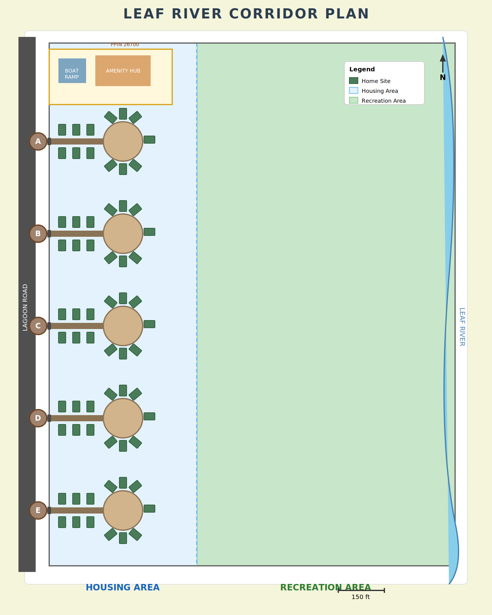
Current zoning allows about 10 homes. The development needs 103 lots.
The trade: dedicate 6 acres as public park in exchange for PMU rezoning at higher density. City gets a riverfront park and Blueways connection. Development gets the lot count that makes the numbers work.
Two things move together:
| Workstream | Purpose |
|---|---|
| Stakeholder Alignment | Build political support so the city wants to approve it |
| Flood Engineering | Prove No-Rise with design that works technically |
These are interdependent. Final design depends on flood engineering. Flood engineering depends on final design. They iterate together.
Political support overcomes planning staff hesitation to approve something in the floodway. When stakeholders want it, approvals follow.
Floodway development is solved engineering. Others have built in floodways using established methods. The technology exists. Density may require accommodation, but accommodation can be made.
Methods
| Method | How It Works |
|---|---|
| Elevated Piers | Slender piers minimize obstruction. Water flows underneath. FEMA allows pier foundations in A zones. |
| Floating Docks | Rise and fall with water level. Minimal riverbed disturbance. Helical anchors instead of fixed pilings. |
| Compensatory Storage | Replace displaced storage volume elsewhere on site. One bucket in, one bucket out. |
| Conveyance Shadow | Locate structures in hydraulic shadow of existing obstructions. Floodwater already flowing around. |
References
- FEMA: No-Rise Certification for Floodways
- FEMA: Compensatory Storage
- FEMA: Floodway Analysis and Mapping Guidance (Document 79)
- Building America: Flood-Resistant Pier, Pile, Post, and Column Foundations
- Reduce Flood Risk: Elevate the Building on Piers
- Southern Green Builders: Custom Homes in Houston Floodplain
- Lafayette Parish: Building within a Floodplain (Compensatory Storage)
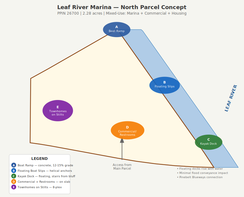
North parcel (PPIN 26700). 2.28 acres at the river confluence. Mixed-use marina, commercial, and housing.
| Component | Description |
|---|---|
| Boat Ramp | Concrete, 12-15% grade at north tip |
| Floating Slips | Helical anchors, rise with water level |
| Kayak Dock | Floating, stairs from bluff, Pinebelt Blueways connection |
| Commercial | Restrooms, bait shop, potential restaurant on existing slab |
| Townhomes | 8-plex on stilts along western edge for boat owners |
4. Product
| Component | Units/Size | Description |
|---|---|---|
| Corridor Housing | 65 homes | Standard tier, Lagoon Road clusters |
| Interior Housing | 30 homes | Premium + Mid-Range, river views |
| Marina Townhomes | 8 units | Premium tier, boat slip access |
| Marina | 2.28 acres | Boat ramp, slips, commercial, kayak |
| Park | ~6 acres | Trails, river access, city dedication |
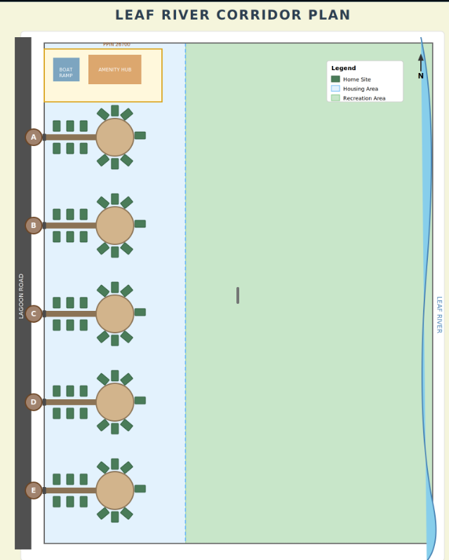
65 homes along Lagoon Road in five clusters (A-E). Standard tier pricing.
| Configuration | 2BR / 2BA |
| Size | 640 SF |
| Elevation | 10 ft on timber pilings |
| Foundation | Slender 8" piers for No-Rise compliance |
| Exterior | Covered porch, stairs |
Design Features
| Layout | Bathroom not through bedroom — accommodates shift schedules |
| Blackout Capability | Night shift workers sleep during day |
| Sound Isolation | No shared walls |
| In-Unit W/D | Standard |
| Covered Parking | Secure, lit |
| Pet-Friendly | Differentiator in this market |
30 homes on two parallel roads through center of site. River views. Premium and Mid-Range tiers.
| Premium | 15 homes — direct river frontage |
| Mid-Range | 15 homes — interior road |
| Size | Larger than corridor units |
| Foundation | Elevated, No-Rise compliant |
Interior housing requires No-Rise certification. Located in main conveyance zone.
8 townhome units on PPIN 26700 at north tip. Premium tier with boat slip access.
| Configuration | 2-story townhome |
| Foundation | Elevated on stilts |
| Parking | Ground level under structure |
| Slip Access | Included with unit |
PPIN 26700 — 2.28 acres at north tip of development.
Components
| Boat Ramp | Public access, connects to Pinebelt Blueway |
| Floating Slips | 40 slips, chain anchor system |
| Kayak Dock | Floating, ADA accessible |
| Commercial Building | 3,000 SF restaurant + 1,000 SF restrooms, elevated |
| Kayak Rental | Movable trailer operation |
No-Rise Approach
| Floating Docks | Rise with water, no obstruction |
| Commercial Structure | Elevated on slender piers |
| Boat Ramp | At-grade, minimal profile |
~6 acres dedicated to City of Hattiesburg. Density offset for PMU approval.
| Location | Central portion between interior and corridor |
| Amenities | Trails, river access, Blueway connection |
| Maintenance | City responsibility after dedication |
Essential Workers
| Hospital Staff | Forrest General — 3,100+ employees |
| Teachers | Hattiesburg School District |
| First Responders | Police, fire, EMS |
| University Staff | USM and William Carey |
| Camp Shelby | Civilian workers |
Second Homes
| USM Alumni | Football weekends, homecoming |
| River Recreation | Kayaking, fishing, hunting access |
| Regional Buyers | Jackson, Gulf Coast — 90 minutes |
Extended Stay
| Patient Families | Forrest General draws from wide region |
| Traveling Nurses | 13-week contracts |
5. Flood Engineering
Floodway vs. Zone AE — different requirements.
Flood Zones
| Effective Date | 11/19/2021 |
| Base Flood Elevation | 144-145 ft |
| Location | Northern and eastern portions — majority of property |
| Corridor Clusters | A, B, C |
| Requirement | No-Rise certification |
| Process | HEC-RAS modeling, PE stamp, FEMA review |
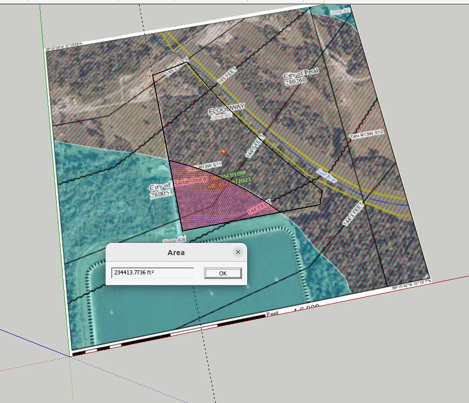
| Location | Southwest corner |
| Size | 234,414 sf (5.38 acres) |
| Corridor Clusters | D, E |
| Requirement | Elevated construction (10 ft on pilings) |
| No-Rise | Not required |
No-Rise Certification
| Regulation | 44 CFR 60.3(d)(3) |
| Standard | Zero increase in flood levels |
| Method | HEC-RAS hydraulic modeling |
| Certification | Professional Engineer stamp |
| Type | 12" diameter creosote-treated wood |
| Height | 10 ft above grade |
| Obstruction | Minimal — circular profile, open underneath |
Slender piers create less flow obstruction than solid foundations.
HEC-RAS Status
| FEMA Data Package | E2504426 acquired |
| Model Status | Not yet built |
| Required For | Clusters A, B, C (floodway) |
| Not Required For | Clusters D, E (Zone AE) |
6. Community Support
Floodway development requires more than engineering — it requires political support.
The Regulatory Reality
| FEMA Position | New development in designated floodways is "extremely restricted" |
| Technical Requirement | No-Rise certification — zero increase in flood levels |
| Political Reality | Communities are cautious about approvals |
| Risk | FEMA can suspend communities from NFIP for violations |
| Consequence | No flood insurance available for any property in the community |
| Result | P&Z tends to deny or delay floodway development requests |
P&Z isn't being difficult — they're protecting the city from FEMA suspension. They need political cover to approve anything in the floodway.
The Approval Pathway
| 1. Community Support | Employers, residents, realtors see value in the project |
| 2. Council Awareness | Constituents communicate support to their council members |
| 3. P&Z Direction | Council signals willingness to approve |
| 4. Technical Review | P&Z evaluates engineering with political cover in place |
| Housing Gap | No inventory in this price range in the market |
| Conservation | ~2/3 of property preserved as recreation/open space |
| Recreation | River access, trails — potential community amenity |
| Workforce Housing | Price point accessible to essential workers |
Building Support
| Organization | Contact | Interest |
|---|---|---|
| Forrest General Hospital | HR | Workforce housing for 3,100+ employees |
| University of Southern Miss | Housing Office, HR | Faculty, staff, graduate students |
| Camp Shelby | Housing Office | Civilian workers, visiting personnel |
| William Carey University | Housing Office | Student/faculty housing |
| Hattiesburg School District | HR | Teacher housing |
Employers with workforce housing needs may advocate for projects that help their employees.
| Purpose | Gauge demand, build awareness |
| Question | What happens when buyers ask for homes in this price range? |
| Value | Realtors who see demand may support new inventory |
| This Website | Available for community review |
| Purpose | Transparent presentation of the project |
| Outcome | Community members can form their own opinions |
Market Context
| City Population | ~48,500 |
| Metro Population | ~157,000 |
| Major Employers | Forrest General, USM, Camp Shelby, William Carey |
| Price Point Gap | Limited new construction at affordable price points |
7. Pro Formas
Pre-development costs and pro forma by component.
Pre-development budget, construction methodology, and financial projections for each development component.
8. Next Steps
Two parallel tracks: coalition building and pre-development engineering.
Coalition Building
| Objective | Test community interest, build support for pre-app meeting |
| Interaction | Technical questions arise — engineering work provides answers |
| Organization | Contact |
|---|---|
| Forrest General Hospital | HR / Workforce Development |
| University of Southern Miss | Housing Office, HR |
| Hattiesburg School District | HR |
| Camp Shelby | Civilian Personnel |
| William Carey University | Housing Office |
| Purpose | Gauge demand at this price point |
| Question | What happens when buyers ask for homes in this range? |
| This Website | Available for community review |
| Purpose | Transparent presentation of the project |
Pre-Development Engineering
Runs parallel to coalition building — answers technical questions as they arise.
| Utilities | Confirm sewer, water, power in Lagoon Road ROW |
| Road Access | Confirm Lagoon Road availability for residential |
| Flood Zones | Verify boundaries — Zone AE vs floodway |
| FEMA Data Package | E2504426 acquired |
| Purpose | No-Rise certification for floodway clusters (A, B, C) |
| Not Required | Clusters D, E (Zone AE) |
| Purpose | Informal review with Hattiesburg Planning |
| Contact | Planning Division — 601-545-4599 |
| Preparation | Coalition support + technical answers in hand |
Development Sequence
| Phase | Cluster | Flood Zone | No-Rise |
|---|---|---|---|
| First | E (southernmost) | Zone AE | Not required |
| Second | D | Zone AE | Not required |
| Third | C | Floodway | Required |
| Fourth | B | Floodway | Required |
| Fifth | A (northernmost) | Floodway | Required |
Start with Zone AE (fewest constraints), work north into floodway.
| Location | PPIN 26700 — north parcel at river's edge |
| Potential | Boat ramp, restaurant/bait shop, community gathering |
| Track | Separate from residential — no timeline pressure |
Budget
9. Cost Analysis System
Proprietary procurement and modeling platform.
Every item in a build is tracked as a component with full specifications.
| Specifications | Requirements for each component |
| Vendors | Qualified suppliers and pricing |
| Installation | Instructions and procedures |
| Maintenance | Service requirements |
After initial qualification, sourcing becomes automatic. The system knows what to order, from whom, at what price.
Components roll up into assemblies. Assemblies roll up into models.
A door assembly includes the door, frame, hardware, weatherstripping, and installation labor. The system tracks all of it as a unit.
This structure allows accurate cost rollups at any level — component, assembly, or complete model.
Each home type gets full cost modeling before construction.
The bill of materials includes every component and assembly required. Pricing updates automatically as vendor quotes change.

Full pro forma analysis with low/expected/high scenarios.
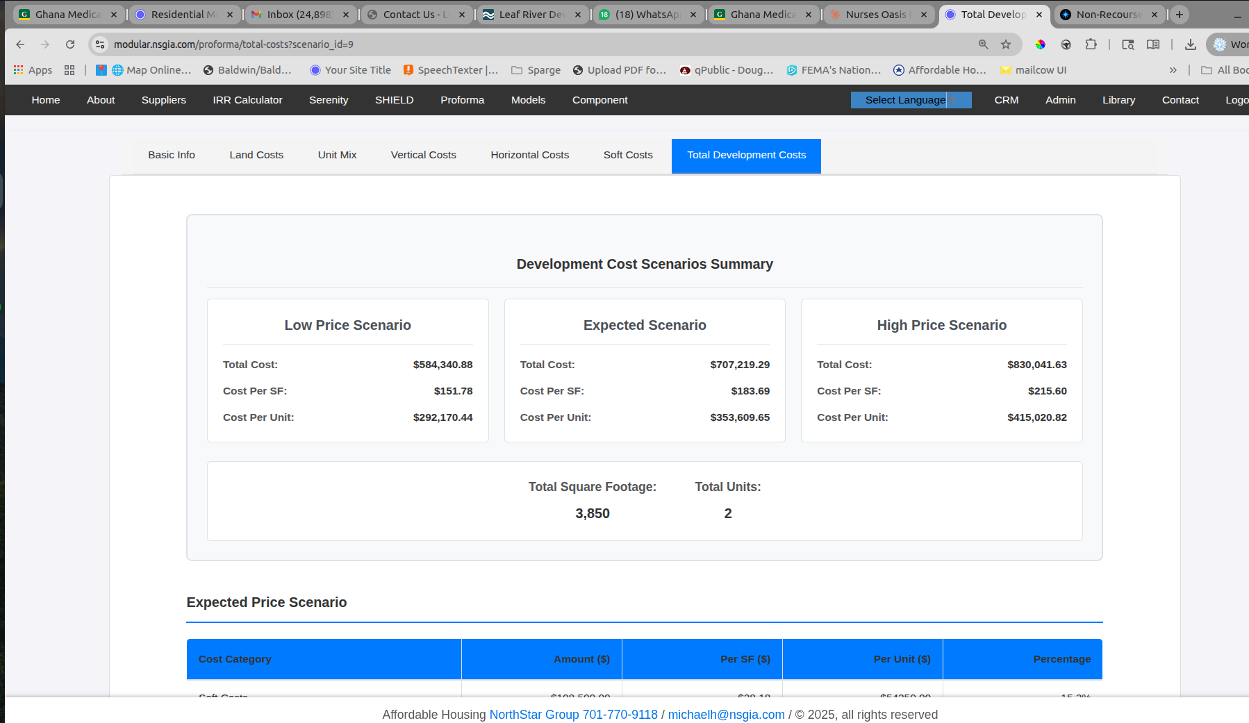
The system calculates total development costs across all units, with per-unit and per-square-foot breakdowns.
Vendors can self-serve to review components and submit bids.

Competitive pricing without manual quote collection. Vendors see specifications and submit pricing directly into the system.
The system generates directive reports for each trade.
A framing report tells the framer exactly what to do — materials list, cut dimensions, installation sequence. No ambiguity, no interpretation required.
Allows skilled workers to execute efficiently without constant supervision.
| Traditional (Big-Box) | Component System |
|---|---|
| Selection controlled by retailer | Quality control at specification level |
| No visibility into substitutions | Transparent pricing from multiple vendors |
| Markup built into every item | Direct vendor relationships |
| Start over every project | Institutional memory that improves over time |
Personal Transportation Included
Every residence includes access to an electric personal transport vehicle for property use.


Electric Passenger Tricycle (Tuk-Tuk)
Three-wheeled electric vehicles used for personal transportation across Asia, Africa, and South America. A cross between a golf cart and a covered scooter — designed for carrying passengers and light cargo.
The name "tuk-tuk" comes from the sound older gasoline models made. Electric versions are nearly silent. In Thailand, India, and across the developing world, tuk-tuks move millions of people daily.
Comparison to Golf Cart
| Feature | Golf Cart | Electric Tuk-Tuk |
|---|---|---|
| Primary Purpose | Golf course transport | Personal/passenger transport |
| Weather Protection | Optional canopy | Full roof + windshield standard |
| Passenger Capacity | 2 (side by side) | 3-6 (driver + rear bench) |
| Cargo Space | Minimal | Rear bench folds for cargo |
| Design Intent | Recreation on manicured courses | Daily transportation on roads |
| Cost (new) | $8,000 - $15,000 | $950 - $1,200 |
Vehicle Specifications
| Specification | Details |
|---|---|
| Motor | 1200W brushless electric |
| Battery | 60V lead-acid or lithium option |
| Max Speed | Governed to 10-15 mph |
| Range | 40-60 km (25-37 miles) per charge |
| Charge Time | 6-8 hours (standard 110V outlet) |
| Passengers | Driver + 3-4 passengers (rear bench) |
| Cargo Mode | Rear bench folds for coolers, gear, etc. |
Safety Features
| Speed Governor | Limited to 10-15 mph |
| Three-Wheel Stability | Low center of gravity, stable at low speeds |
| Full Canopy Roof | Protection from sun and rain |
| Windshield | Front wind/debris protection |
| Headlights/Taillights | LED lighting for visibility |
| Brakes | Hydraulic disc brakes, all wheels |


Intended Use
| River access | Transport from residence to waterfront |
| Gear hauling | Fishing equipment, coolers, kayaks |
| Passenger transport | Friends, family, guests |
| Community events | Shuttle to pavilion, common areas |
Limitations
| Public roads | Not street legal (speed-limited) |
| Off-property use | Not intended |
Charging & Storage
| Charging | Standard 110V outlet at residence |
| Cost to Charge | ~$0.50-1.00 per full charge |
| Storage | Outdoors; covered parking optional |
| Maintenance | Battery, tires, brakes |
Similar to golf carts from an insurance perspective. Most homeowner's policies can add a rider for low-speed vehicles on private property.
| Option | How It Works |
|---|---|
| Homeowner's Policy Rider | ~$50-100/year added to existing policy |
| Golf Cart Insurance | Standalone, typically $100-200/year |
| HOA Umbrella | Community may provide liability for common-area use |
Each resident is responsible for insuring their assigned vehicle.
Fleet Cost (~65 Units)
| Item | Unit Cost | ~65 Units |
|---|---|---|
| Vehicle (20+ unit pricing) | $958 | $62,270 |
| Shipping (est. container freight) | $150 | $9,750 |
| Assembly/prep | $50 | $3,250 |
| Total | ~$1,158 | ~$75,270 |
Per-Unit Impact
| Cost per home | ~$1,160 |
| Differentiator | No competing development offers this |
| Comparable cost | Less than an appliance upgrade package |
Current Specification: Sunsen Bajaj Electric Tuktuk
| Manufacturer | Meishan Sunsen New Energy Vehicle Co., Ltd. |
| Alibaba Status | Verified Custom Manufacturer (2+ years) |
| Model | 1200W Electric Passenger Tricycle |
| Material | Flame Retardant |
| Customization | Minor, drawing-based, sample-based, or full custom |
Volume Pricing
| Quantity | Price/Unit |
|---|---|
| 1 unit | $1,158 |
| 2-19 units | $1,058 |
| 20+ units | $958 |
Customization Options
| Speed governor | Factory limit to 15 km/h (9 mph) or 25 km/h (15 mph) |
| Color | Consistent fleet color (yellow, blue, or custom) |
| Branding | "Oasis" or "Leaf River" decals |
| Battery upgrade | Lithium option for longer life |
Product Link: View on Alibaba →
11. The Land & The River
A reference guide for visitors to the upper Leaf River at Hattiesburg.
The Leaf River
The upper Leaf River near Hattiesburg has an excellent reputation for water quality. Paddlers regularly swim at sandbars throughout this section. The Seven Rivers Canoe Club documents swimming at confluence points and sandbars as routine.
The Leaf runs warmer than its tributaries. At the Oakahay Creek confluence, paddlers note the Leaf is "markedly warmer and of a lighter, muddy tint" than incoming streams. The river is deeper with stronger current at these points—swimming into the main channel from tributaries requires awareness that combined currents may push swimmers downstream.
Water Quality Context: A 1990s lawsuit alleged pollution from a Georgia-Pacific pulp mill on the lower Leaf River (downstream, toward the Gulf). Courts dismissed the case in 1996, finding no scientific proof of dangerous dioxin levels. The upper Leaf near Hattiesburg—the section adjacent to this property—was not part of that litigation and maintains its reputation as clean water.
Fish Consumption: Mississippi Department of Wildlife, Fisheries and Parks rates upper Leaf water quality as "average to above average." The Leaf River does not appear on Mississippi's Fish Consumption Advisory list.
After Heavy Rain: Standard river safety applies. Avoid swimming within 48 hours of major rain events when bacteria levels temporarily spike from runoff.
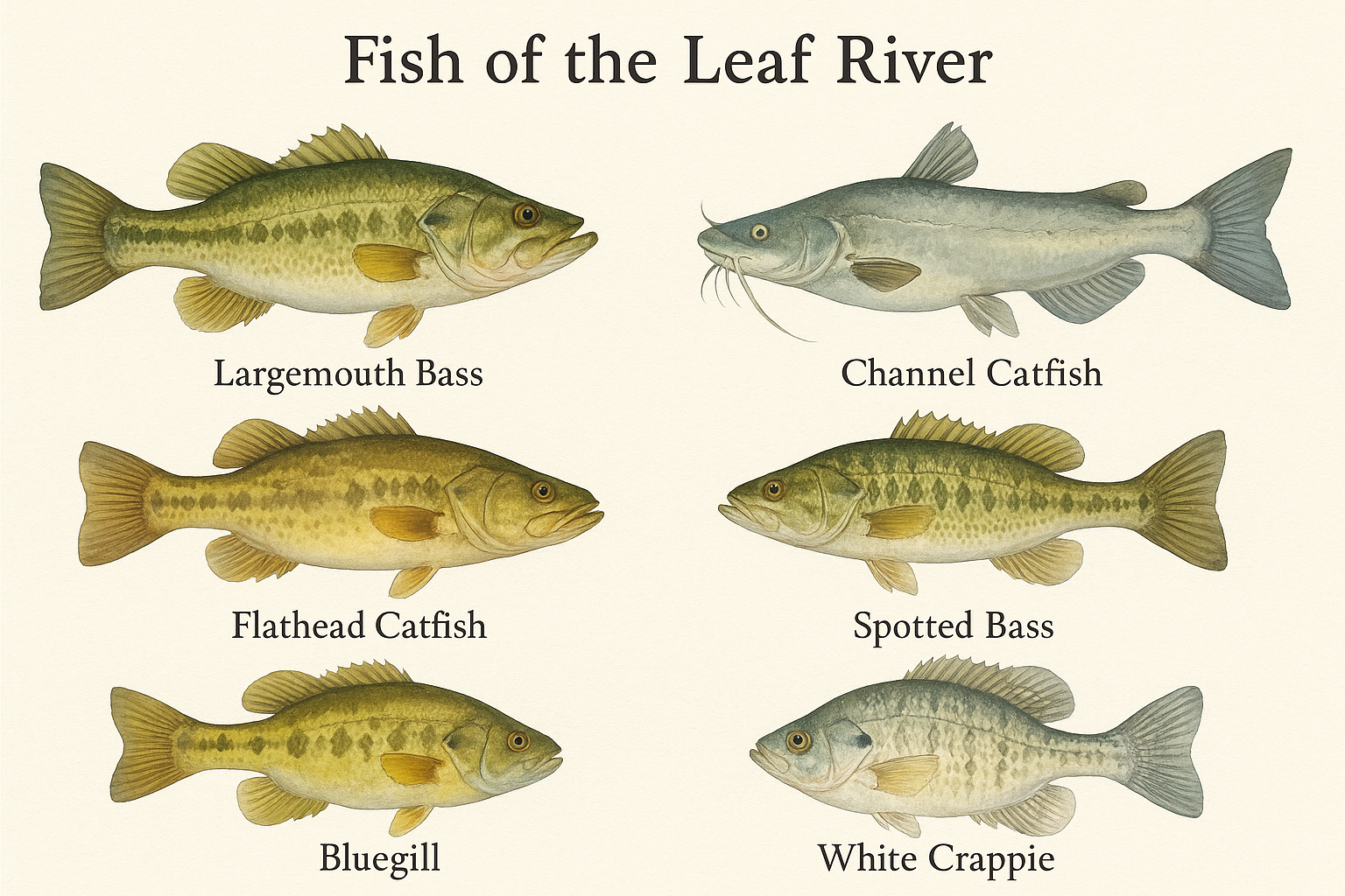
The Leaf River supports diverse gamefish populations. MDWFP documents:
Bass Species: Largemouth bass, Spotted bass, Striped bass
Catfish Species: Channel catfish, Flathead catfish, Blue catfish, Yellow catfish
Panfish: Bluegill/Bream, White crappie, Black crappie
Other Species: Freshwater drum, Paddlefish (spawning runs), Gulf sturgeon (protected, catch and release only), Alabama shad
Habitat: The river is described as "full of trees, stumps, ever-changing bottom structure"—excellent cover for fish populations. Numerous sandbars and shallows alternate with deeper pools.
River characteristics vary by section and water level. At the Hattiesburg gauge:
Normal Conditions: The river runs wide with alternating deep pools and shallow sandbars. Paddlers describe sections as "very deep and wide" at confluences.
High Water Reference: When the Hattiesburg gauge reads over 5 feet, the river runs deep throughout with strong current. At these levels, combined currents are too much to swim against.
Current: Flow varies significantly. Headwinds can make paddling difficult on wider sections. Current strengthens at tributary confluences and through narrower channels.
Real-Time Data: USGS maintains a streamgage at Hattiesburg (Station 02473000) with current depth and flow readings available online.
The Leaf River floods periodically. Major recorded crests at Hattiesburg:
| Date | Crest Height | Notes |
|---|---|---|
| April 15, 1974 | 34.03 feet | All-time record. 6,000 evacuated from Forrest County. |
| February 1961 | 31.53 feet | Record at that time. Nearly 5,000 evacuated. |
| April 1983 | Major flood | Bridges washed out, 300+ structures damaged. $50M damages. |
Context: The Oasis property includes approximately 25 acres in the regulatory floodway and 5 acres in Zone AE. All construction is elevated on piers 10 ft above grade to meet flood requirements.
Six Towns History

The Choctaw people inhabited this region for centuries before European contact. The upper Leaf River watershed was homeland to the Okla Hannali—the "Six Towns" division, one of three principal Choctaw political groups.
The Three Divisions:
- Okla Falaya ("Long People") — Western division, upper Pearl River
- Okla Tannap ("People on the Other Side") — Eastern division, Tombigbee River area
- Okla Hannali ("Six Towns People") — Southern division, upper Leaf River and mid-Chickasawhay River watersheds
The Six Towns villages concentrated in present-day Jasper, Newton, and Clarke counties—directly upstream from Hattiesburg.
The Leaf River carried multiple Choctaw names, all sharing linguistic roots meaning "creek" or "river": Hashuphatchee, Hastabucha, Hastehatchee, Estapacha, Estopacha, Slapacha, Tallahoma.
The suffixes "-hatchee" and "-bucha" derive from Choctaw words for creek or river. These names appear on French colonial maps and in early American survey records.
How "Leaf River" Emerged: English-speaking settlers translated or adapted the indigenous name. The exact derivation is unclear—possibly a translation of a Choctaw descriptive term, or an English name based on the river's appearance.
The Leaf River served as a trade route before roads existed. Historical records document regular trading trips from Pascagoula (on the Gulf Coast) upriver to Choctaw settlements. Traders brought manufactured goods and supplies to Six Towns villages. The river provided the primary transportation corridor through this region.
Human use of the Leaf River corridor extends back at least 25,000 years based on archaeological evidence from the broader Pascagoula watershed.
The Spanish Coins Legend: Local tradition holds that Spanish traders cached coins somewhere along the upper Leaf River. Whether fact or folklore, the story reflects the river's long history as a commercial corridor connecting the Gulf Coast to interior settlements.
Flora & Fauna
The Leaf River corridor lies within the Southern Pine Hills region. Forest composition varies by elevation and moisture:
Uplands: Longleaf pine, slash pine, loblolly pine. Historic longleaf savanna largely converted to pine plantation or mixed forest.
Bottomlands: Sweetgum, water oak, willow oak, tupelo, cypress (in wetter areas). Dense understory typical.
River Edge: River birch, sycamore, willow. Sandbars may support early-succession species.
Mammals: White-tailed deer (paddlers report seeing deer wading across the river), Wild hogs, Raccoon, Opossum, Beaver, River otter, Gray and fox squirrels, Black bear (population recovering; occasional sightings)
Birds: The Pascagoula River system supports 327 documented bird species. Notable: Bald eagle (confirmed along the Leaf River), Great blue heron, various waterfowl, Wild turkey, Northern bobwhite, Red-cockaded woodpecker (endangered)
Reptiles: American alligator (Mississippi's official state reptile), various turtles including snapping turtles, multiple nonvenomous snake species
Mississippi has six venomous snake species. All may be present in the Leaf River corridor:
| Snake | Length | Habitat |
|---|---|---|
| Cottonmouth (Water Moccasin) | 2–4 ft | Near fresh water, riverbanks |
| Copperhead | 2–3 ft | Leaf litter near forests |
| Canebrake/Timber Rattlesnake | 3–4.5 ft | Forests and river bottoms |
| Eastern Diamondback | 4–5.5 ft | Sandy pinewoods |
| Pygmy Rattlesnake | 18–20 in | Flatwoods, swamp edges |
| Coral Snake | 2–3 ft | Sandy pinewoods, southeastern counties |
Practical Notes: 75% of venomous snakebites occur when someone attempts to kill or handle a snake. Most snakes avoid human contact if undisturbed. "Dead" snakes can bite reflexively.
The Ground
The Hattiesburg area lies within the Southern Coastal Plain geological region, specifically the Piney Woods subregion.
Soil Characteristics: Mixture of sand and clay. Sandy loam topsoil over clayey subsoil typical. Acidic pH (pine and oak decomposition produces organic acids). Low to moderate native fertility. Well-drained on uplands; wet in bottomlands.
Geological Formation: The Citronelle Formation underlies this area—ancient marine and fluvial sediments deposited on the edges of prehistoric seas. The geology dates to when the Gulf of Mexico extended much further inland.
Sandy. The Piney Woods soils developed from unconsolidated sediments, not bedrock. River sandbars throughout the Leaf are prominent features—paddlers describe "numerous beautiful sand bars" and "white sandbars" along the entire corridor.
Upland soils contain more clay than bottomland soils. The typical profile: sandy loam surface layer over clay or clay loam subsoil.
No significant rock outcrops occur in this region. The nearest limestone and chalk formations are in the Blackland Prairie region to the north.
Coastal Plain soils generally support construction with proper site preparation.
Favorable Factors: No bedrock to excavate. Sandy soils easy to work. Established construction history throughout region.
Site-Specific Factors: Clay content varies; shrink-swell clays require appropriate foundation design. Drainage critical on sites with shallow water table. Flood zone determination essential for sites near river.
The Oasis property is within regulatory flood zones (floodway and Zone AE). All structures are designed for elevated pier foundations.
Weather & Climate
Hattiesburg has a humid subtropical climate (Köppen classification: Cfa).
Characteristics: Long, hot, humid summers. Short, mild winters. Rainfall distributed throughout the year. No dry season.
| Season | Avg High | Avg Low | Notes |
|---|---|---|---|
| Summer (Jun–Aug) | 90–91°F | 70–72°F | Hot season mid-May through late September |
| Fall (Sep–Nov) | 67–88°F | 47–67°F | Pleasant; driest months |
| Winter (Dec–Feb) | 57–65°F | 40–43°F | Mild; occasional freezes |
| Spring (Mar–May) | 72–85°F | 49–63°F | Warming rapidly; thunderstorm season begins |
Hottest Month: July (average high 91°F). Coldest Month: January (average high 61°F).
Annual precipitation averages approximately 50–61 inches, among the highest in Mississippi.
Wettest Period: July (most rainy days, 16.4 days average)
Driest Period: October (fewest rainy days, 6.6 days; lowest total rainfall, 3.1")
Pattern: Summer rainfall comes primarily from afternoon thunderstorms. Winter/spring rainfall from frontal systems moving through the region.
General Outdoor Activities: Early April through late May. Mid-September through late October. Peak conditions: First week of October.
Water Activities (Swimming, Paddling): Mid-May through late September. Peak conditions: First week of September.
Growing Season: 8.5 months (approximately March 6 through November 21). First spring blooms typically appear around January 20. Frost-free period averages 260 days.
Thunderstorms: 55–75 days per year with thunderstorm activity. Frequency increases moving south toward the Gulf Coast.
Hurricanes: South Mississippi is within the hurricane impact zone. Hattiesburg lies 75 miles inland—far enough to avoid direct coastal impacts but subject to heavy rain, wind, and flooding from major storms. Hurricane Camille (1969) produced 120 mph sustained winds at Columbia, Mississippi.
Tornadoes: Mississippi lies within "Dixie Alley"—the southeastern tornado zone. Spring months carry highest risk.
12. Engineering Pre-Development
Task list for civil engineer — items to verify in parallel with coalition building.
Site Drawings & Downloads
Survey-quality parcel boundaries with dimensions. NAD83 State Plane Mississippi East (EPSG:2254), units in US Survey Feet.
| Format | Use Case | Download |
|---|---|---|
| DXF | AutoCAD, Civil 3D, landscape design software | leaf_river_parcels.dxf |
| PNG | Presentations, quick reference, print | leaf_river_parcels.png |
| Shapefile | GIS software (QGIS, ArcGIS, HEC-RAS) | leafShape.zip |
Parcel Summary:
| Owner | Acres | Sq Ft |
|---|---|---|
| Montgomery Roger | 2.28 | 99,207 |
| Landrum John Allen & Gerald W | 28.88 | 1,258,162 |
| Total | 31.16 | 1,357,369 |
Overall Extent: 1,508' × 1,644'
| Document | Description | Download |
|---|---|---|
| No-Rise Documentation | FEMA data package, HEC-RAS methodology | No-Rise Package.pdf |
| MS Blueways Guide | State guidelines for waterway access design | MS Blueways Guide.pdf |
| FIRMETTE (26786) | FEMA flood map for primary parcel | FIRMETTE.pdf |
Site Verification
| Utility | Question | Impact if Missing |
|---|---|---|
| Water | Water main in Lagoon Road? | Major cost to extend |
| Sewer | Sewer line, or septic required? | Individual septic = $5-8K/unit |
| Electric | Power available at road? | Transformer/service extension |
| Gas | Natural gas available? | All-electric design if not |
Contact: City of Hattiesburg Engineering Department
| Service | Estimated | Verify With |
|---|---|---|
| Water tap | $500-1,500 | Hattiesburg Water & Sewer |
| Sewer tap | $500-2,000 | Hattiesburg Water & Sewer |
| Electric service | $500-1,500 | Mississippi Power |
| Total Range | $1,500-5,000/unit |
Budget assumption: $2,000/unit. Actual quotes required.
| Access Road | Lagoon Road (western edge of property) |
| Verify | Road status, right-of-way, residential access permitted |
| Private Drives | 5 (one per cluster) |
Flood Zone Engineering
| Zone | Acreage | Clusters | Requirement |
|---|---|---|---|
| Floodway | ~25 acres | A, B, C | No-Rise certification required |
| Zone AE | ~5 acres | D, E | Elevated construction, no No-Rise |
| Base Flood Elevation | TBD — verify from FIRM panel |
| Required Elevation | BFE + 1 ft freeboard (typical) |
| Design Elevation | 10 ft above grade — verify exceeds BFE + freeboard |
| Permit | Floodplain development permit |
| Documentation | Elevation Certificate required |
| Regulation | 44 CFR 60.3(d)(3) |
| Requirement | No-Rise certification — PE-stamped |
| Analysis | HEC-RAS hydraulic modeling |
| FEMA Data | Package E2504426 acquired |
| Model Status | Not yet built |
No-Rise demonstrates that proposed construction does not increase flood levels. Pier foundations on elevated structures typically pass — minimal hydraulic obstruction.
| Stage | Action |
|---|---|
| Before construction | Survey establishes benchmark and reference elevation |
| Foundation complete | Surveyor certifies top-of-pier elevation |
| Structure placed | Surveyor certifies finished floor elevation |
| Final | Submitted with CO application, required for flood insurance |
Cost: $300-500 per Elevation Certificate (typically 2 required)
Foundation Engineering
| Specification | Value |
|---|---|
| Structure | Two 40' high-cube containers side-by-side (640 sf) |
| Dead load | ~10,000 lbs per container (empty) + finishes |
| Live load | 40 psf residential |
| Elevation | 10 ft above grade (finished floor) |
| Pier type | Creosote-treated wood, 12" diameter |
| Pier count | 6 per unit (preliminary) |
| Embedment | 5 ft below grade (preliminary) |
Engineering Deliverables
| Soil bearing capacity verification | May need geotech |
| Pier sizing and spacing calculations | |
| Wind load analysis | Hurricane zone |
| Connection detail | Pier to cap plate to container |
| PE-stamped drawings | Required for permit |
Budget estimate: $2,000-5,000 for PE-stamped foundation design
| Method | Cost | Site Requirements |
|---|---|---|
| Crane + operator | $800-2,500/unit | Outrigger space, overhead clearance |
| Container handler | ~$250/unit (batch) | Level ground, turning radius |
Verify: Can reach stacker access all 5 cluster drives? Turning radius ~25-30 ft.
Source: Port equipment rental (Gulfport, Mobile)
Site Infrastructure
| Item | Specification |
|---|---|
| Count | 5 (one per cluster) |
| Width | 12-14 ft (confirm for two-way) |
| Surface | Gravel (crushed limestone or similar) |
| Cost estimate | ~$20/linear foot — get local quote |
| Question | Impact |
|---|---|
| Total disturbed area? | >1 acre typically triggers SWPPP |
| Impervious surface added? | Container footprints + drives |
| Existing drainage? | Sheet flow to river vs. defined channels |
| City requirements? | Hattiesburg stormwater ordinance |
Elevated structures on piers have minimal ground disturbance. Gravel drives are semi-pervious. May qualify for simplified review.
Permitting
| Permit | Authority | Trigger |
|---|---|---|
| Building Permit | City of Hattiesburg | Each structure |
| Floodplain Development | Floodplain Administrator | All construction (Zone AE and Floodway) |
| No-Rise Certification | FEMA via local admin | Floodway only (clusters A, B, C) |
| Electrical Permit | City of Hattiesburg | Service connections |
| Plumbing Permit | City of Hattiesburg | Water/sewer connections |
| SWPPP/NOI | MDEQ | If >1 acre disturbed |
| Driveway Permit | City/County | New curb cuts |
Cost Verification
| Item | Current Estimate | Quote From |
|---|---|---|
| Utility tap fees | $2,000/unit | Hattiesburg utilities |
| Gravel drives | $20/lf | Local grading contractor |
| Wood pier foundation | $1,600/unit installed | Local pile contractor |
| PE foundation design | $2,000-5,000 | Structural engineer |
| Stairs/deck (prefab steel) | $2,500/unit | Fabricator |
| Container handler rental | $2,000-4,000 total | Port equipment yard |
| No-Rise modeling | TBD | Hydraulic engineer |
Pre-Application Meeting
| Topic | Preparation |
|---|---|
| Site conditions | Walk property, document access points |
| Utilities | Verification status — confirmed vs. unknown |
| Flood zones | BFE, elevation requirements, No-Rise path |
| Foundation | Wood pier approach, engineering scope |
| Phasing | Start with Zone AE (clusters D, E), then floodway |
| Permitting | Critical path items |
| Coalition support | Community interest documentation |
Contact: Hattiesburg Planning Division — 601-545-4599
13. North Star Services
Development consulting from feasibility through completion.
- Finds deal-killers early when they're cheap to discover
- Identifies problems before capital is committed
- Reduces risk for investors and lenders
- Builds relationships with planning staff before formal submission
- Tests concepts in pre-application meetings
- Identifies regulatory obstacles early
- Shows the numbers work before spending construction money
- Construction lenders require predevelopment work before funding
- Investors need feasibility proof before committing
- Creates win-win scenarios for neighbors and the city
- Turns potential opponents into supporters
- Generates political cover for decision-makers
- Design decisions made now determine construction cost later
- Changes are cheap on paper, expensive in concrete
- Value engineering happens before plans are final
PRELIMINARY VISION: This document represents initial planning concepts only. All configurations and unit counts are subject to revision by the landowners prior to any pre-development meetings.
The landowners' original vision for the northern portion:
- Single-family housing
- Boat ramp, marina access, kayak launch
- Potential commercial component
Additional housing along the western edge may be developed if beneficial to the landowners' overall vision. The extent of corridor development depends on factors including zoning, market conditions, and landowner preferences.
A portion of the riverfront may be preserved as a community park with public river access, supporting the City's Pinebelt Blueways initiative.
Potential amenities (to be determined): fishing piers, cooking areas, picnic pavilions and benches, canoe/kayak launch, walking trails.
Park size and configuration would be determined based on final development layout and any density negotiations with the city.
Preliminary target under R-1A zoning assumptions, or alternatively a Planned Unit Development (PUD) if beneficial. Actual unit count depends on:
- Final configuration chosen by landowners
- Park allocation
- Infrastructure requirements
- Zoning approval
The development may include rental units, homes for sale, or a combination. Final mix to be determined based on market conditions and landowner preferences.
Floodway development requires more than engineering — it requires political support. Cities are cautious about floodway approvals because FEMA can suspend communities from the National Flood Insurance Program for violations. Planning staff needs political cover to say yes.
- Stakeholder Mapping — Who has power and influence? Who's affected? City council, planning staff, adjacent neighbors, community groups
- Early Engagement — Building relationships before formal approvals, not after opposition forms
- Mobilizing Supporters — Finding and activating allies is often more important than converting opponents
- Addressing Concerns Proactively — Traffic, property values, infrastructure, neighborhood character
- Relationship Building — With elected officials and city staff
- Understanding the Approval Process — What path is needed? What's the timeline? Who votes?
The 5-7 acre riverfront park changes the equation from "developer asking for something" to "mutually beneficial arrangement." A public park with river access benefits both the community and the development.
Potential amenities (to be determined): fishing piers, cooking areas, picnic pavilions and benches, canoe/kayak launch, walking trails, and other features that serve the community.
The park aligns with the City's existing Pinebelt Blueways initiative and investment in river access.
Development in a floodway requires more than technical compliance — it requires demonstrating to city staff and elected officials that the project team has anticipated concerns, engaged appropriate professionals, and prepared documentation aligned with municipal planning standards.
The objective is to arrive at the pre-development meeting with a project package that reflects systematic due diligence across all relevant dimensions. This means engaging stakeholders and gathering informal feedback before formal submission, so the project presented to decision-makers has already been shaped by community input and staff guidance.
This is not a request for permission to explore an idea. It is a presentation of professional work product that demonstrates the project is feasible, financially sound, and responsive to city priorities.
Representative, not exhaustive — additional areas will be addressed as project scope and stakeholder input require:
- Regulatory & Compliance — Zoning, environmental review, floodway requirements, FEMA coordination, permitting pathway
- Engineering & Technical — Civil, structural, utilities, drainage, fire and life safety, infrastructure capacity
- Financial & Feasibility — Development budget, financing structure, pro forma, risk assessment, contingencies
- Community & Context — Neighborhood impact, public benefit, alignment with city comprehensive plan and initiatives
Each area should be addressed at a level that demonstrates professional competence and proactive problem-solving — not final construction documents, but sufficient analysis that planning staff can evaluate the approach without requiring extensive follow-up.
| Phase | Objective |
|---|---|
| Pre-Engagement | Complete technical assessments and financial modeling sufficient to demonstrate viability |
| Stakeholder Input | Seek informal feedback from community contacts and city staff; incorporate into project refinement |
| Pre-Development Meeting | Present professionally prepared package reflecting prior engagement |
| Formal Submission | Submit complete application with documentation addressing all identified requirements |
North Star Group may engage local consultants, connectors, or representatives to conduct stakeholder outreach and gather feedback. The strategy is to build technical and community support before engaging officials with approval authority — ensuring the project arrives at formal review with momentum rather than as an unknown quantity.
No-Rise certification determines the development program. Until this is resolved, the scope of development remains variable.
Gate: FEMA requires proof that development will not increase flood levels (44 CFR 60.3(d)(3)). The hydraulic analysis determines how many homes can be built and where.
| Scenario | Location | Homes | Flood Zone |
|---|---|---|---|
| Owner's North Development | PPIN 26700 (8 townhomes) + interior north (32 homes) | 40 | All floodway |
| Lagoon Road Corridor | Western edge, clusters A-E | 35-48 | A,B,C floodway / D,E Zone AE |
The combined vision melds both plans if hydraulics permit. If the concentrated north layout causes a rise, the corridor plan (peripheral location, lower velocity zone) becomes the primary development area.
| Near channel (north interior) | Higher velocity, more sensitive to obstruction |
| Floodway edge (Lagoon Road) | Water spreads, velocity drops, pooling zone — easier No-Rise |
| Zone AE (clusters D, E) | No No-Rise required — elevated construction only |
Slender piers spaced more than 10 diameters apart do not create hydraulic mass — each pier acts independently with no wake interference. Smaller diameter = less obstruction = better No-Rise margin.
| Material | Southern Yellow Pine, creosote pressure-treated |
| Diameter | 8" butt / 6" tip (tapered) |
| Piers per home | 9 |
| Shape | Round — minimizes drag coefficient |
Structural capacity: A 6" tip timber pile at 1,200 psi allowable stress supports ~17 tons. Actual load per pile is ~6 tons — a 3× safety margin.
| Load Component | Calculation |
|---|---|
| Dead load (1,500 SF home) | 30 psf × 1,500 = 45,000 lbs |
| Live load | 40 psf × 1,500 = 60,000 lbs |
| Total load | 105,000 lbs ÷ 9 piles = ~6 tons/pile |
Code reference: Piles under 25 tons capacity require minimum 6" tip (IBC 1811.5.4, ASTM D25). Our 6-ton load is well under threshold.
Smaller piers create less obstruction and require less spacing to avoid wake interference:
| Pier Diameter | Obstruction Width | Min Spacing (>10D) |
|---|---|---|
| 6 inch | 0.5 ft | 5 ft |
| 8 inch | 0.67 ft | 6.7 ft |
| 12 inch | 1.0 ft | 10 ft |
At 6" diameter with homes spaced 30+ ft apart, pier spacing far exceeds the 10-diameter threshold. Wakes do not interact — each pier acts independently.
| Wake interaction threshold | Spacing > 10 diameters = no interaction (Guragain et al., 2024) |
| Obstruction ratio limit | < 2% of flow area = negligible impact (Zhang et al., 2025) |
| Modeling method | Blocked obstruction in HEC-RAS (FEMA Doc 79, USACE guidance) |
FEMA accepts the blocked-obstruction approach for slender structural elements when obstruction ratio is minimal and piers are spaced to prevent wake interaction.
| Model | HEC-RAS 6.5, FEMA effective model extended |
| Design flow | 25,000 cfs (1% annual chance) |
| WSEL without piers | 46.73 ft |
| WSEL with piers | 46.73 ft |
| Rise | 0.00 ft |
Professional engineer certification required. Preliminary model built by NSG; PE review by River Science, LLC.
| FEMA data package | Acquired (E2504426, $1,179) |
| Preliminary model | Built by NSG — 0.00 ft rise |
| PE engaged | Jill Butler, P.E., CFM — River Science, LLC |
| Fee proposal | $3,220 (28 hours @ $115) |
| Scope | Duplicate effective model, corrected model, proposed conditions |
| Pending | Owner's revised layout to be delivered to engineer |
We start with the maximum development program — all amenities, the owner's interior buildout, and the Lagoon Road corridor. This combined vision yields the highest density and greatest return.
If the full program doesn't achieve No-Rise, we back off components until we reach an achievable scope. Jill's modeling will identify which elements (if any) push the water surface past the 0.00 ft threshold. We can then remove or relocate those specific components while preserving the rest of the development.
For example, if 40 interior homes plus 35 corridor homes causes a rise, but 40 interior homes alone does not, we know the corridor homes in the floodway are the limiting factor. We might relocate some corridor density to Zone AE (clusters D, E) where No-Rise doesn't apply.
Bottom line: Jill's analysis defines the buildable scope. We don't guess — we model, then adjust.
- Engineering Section 12: Technical details, HEC-RAS methodology, PE deliverables
- Development Vision (above): North Development and Corridor Plan descriptions
- Amenity Hub (Section 8): Marina zones, floating docks, townhome component
Development Framework
Built a system that organizes the project into understandable parts — where things stand, what's decided, what's open. The individual tasks (market research, flood mapping, cost estimates) are straightforward. The value is having them organized so the owners can see the whole picture, other team members can find what they need, and updates happen in one place rather than scattered across emails and documents.
Site Plan Approach
The landowner's plan focuses on the north riverfront section with marina and amenity hub. NSG added the Lagoon Road west corridor as an alternative — outer edge of the floodway where water pools rather than flows. Both plans go to the pre-application meeting along with a 5-7 acre park. Maximum entitlements if all three get approved; project still works if scope gets reduced.
Owner Presentation Website
leafriver.nsgia.com holds everything — market, property, flood, budget, engineering, services. Tabs update as information comes in. A public-facing version can spin off for employer outreach once the development path is set.
This is different from a traditional feasibility study that gets delivered once and sits in a drawer. The website is the deliverable, and it keeps getting better.
Marina/Amenity Hub Concept
Researched floating dock systems in floodway conditions — helical anchors, timber pile sizing, configurations that can satisfy No-Rise requirements. A few comparable facilities documented. The concept is figured out; engineering details come after the city indicates willingness.
Predevelopment Checklist
19 areas organized with status and open questions. Park and marina are conceptual; documentation follows as decisions get made.
Open Item
Scope has changed since the original engineering services package. The No-Rise engineer needs an updated brief before completing the study.
Why this matters: The product needs to work on three dimensions: desirable to buyers, buildable at a profit, and priced for the market.
| Desirable | Planning staff and council members would want to live there themselves. |
| Buildable | Construction cost leaves margin. This is the biggest variable in the pro forma. |
| Right-sized | Priced within the target market's reach while delivering perceived value. |
| Profitable | The numbers work for everyone involved. |
The detailed market analysis is in Section 1: Market. Summary:
| Metro households | 61,290 |
| Qualified at $200K purchase | ~16,500 (27%) |
| Homes needed | Fewer than 100 |
| Penetration required | Less than 1% |
Demand exists. The question is whether the product fits what buyers want at a price they can afford.
- Does the design appeal to target buyers?
- Would local realtors list these homes?
- Do planning staff see this as an asset to the community?
- Can construction cost targets be met while delivering quality?
| Initial Design Testing | Preliminary renderings for feedback. Offshore architect keeps iteration cost low. |
| Realtor Validation | Show renderings to local agents. Would they list it? |
| Construction Cost Check | Can the design be built at target cost? |
| Design Refinement | Iterate based on feedback while costs are low. |
| Licensed Architect | Mississippi-licensed architect for construction documents once design is validated. |
Risk Level: Medium. Design decisions affect long-term livability and resale. Worth getting right early.
Why this matters: Recent purchase means a current title commitment exists. Development-specific issues may not have been flagged in a standard title search.
| Parcel | Status |
|---|---|
| PPIN 26786 (Rayborn) | 27.2 acres — primary parcel, recently purchased |
| PPIN 26700 (Montgomery) | 2.3 acres — amenity hub |
| PPIN 26793 (Forrest County) | Abandoned ROW between parcels |
The county ROW parcel (PPIN 26793) sits between the two development parcels. Resolution options:
- Vacation — City/county transfers ownership
- Easement — Access rights granted without ownership transfer
This is a known issue with a clear path — city/county cooperation determines timing.
- Obtain title commitment from owner (recent purchase) or title company
- Review Schedule B exceptions for anything affecting site layout or access
- Prepare ROW resolution request for pre-development meeting discussion
Risk Level: Medium. ROW resolution is a known issue with a clear path.
Why this matters: There are multiple paths forward with different levels of complexity. The choice of path affects time, money, and risk. Harder paths take longer and require more predevelopment work — but may reduce construction costs or increase value.
| Current zoning | A-1 Agricultural |
| Density allowed | 1 dwelling per 3 acres |
| Homes allowed by right | ~10 on 31 acres |
Paths listed from easiest to hardest. Each step up increases complexity and predevelopment cost.
| Path | What It Gets | Difficulty |
|---|---|---|
| Stay A-1 (by right) | ~10 homes. No rezoning. | Lowest |
| Lagoon Road Only | Housing off existing road. No internal circulation. | Low |
| R-1A Rezoning | ~88 homes (4.4/acre). Public streets required. | Medium |
| R-1B / R-1C Rezoning | Higher density (~116-146 homes). Public streets required. | Medium-High |
| Planned Unit Development (PUD) | Negotiated density. Private roads. Park credit. Layout flexibility. Confirmed available. | Highest |
| Predevelopment Budget | Harder paths require more professional services |
| Timeline | More complex approvals take longer |
| Risk | More complex approvals have more ways to stall |
| Construction Budget | Public streets cost more than private roads |
| Ultimate Value | More homes generally means more total value |
Part of predevelopment work is determining which path fits.
Hattiesburg has a Section 91 PUD ordinance that fits this project.
| Requirement | Section 91 | This Site |
|---|---|---|
| Minimum acreage | 5 acres | 31 acres ✓ |
| Minimum lot size | None — clustering permitted | Flexible ✓ |
| Private streets | Allowed with Site Plan Review approval | Cost savings ✓ |
| Park dedication | City accepts maintenance if location/nature approved | Blueways alignment ✓ |
| HOA | Required — automatic membership, covenants run with land | Standard |
| Commercial limit | Max 25% of land area | Marina/amenity hub fits |
Approval path: Site Plan Review Committee → Planning Commission → City Council
The additional predevelopment cost and time may be offset by infrastructure savings (private roads vs. public streets).
| Zone | Min Lot | Density | Yield (20 net acres) |
|---|---|---|---|
| R-1A | 10,000 sf | ~4.4/acre | ~88 |
| R-1B | 7,500 sf | ~5.8/acre | ~116 |
| R-1C | 6,000 sf | ~7.3/acre | ~146 |
R-1 paths require public streets built to city standards.
| Question | Status |
|---|---|
| Is PUD available? | Yes. Section 91 confirmed. |
| Can private roads be approved under PUD? | Yes. With Site Plan Review approval. |
| Park dedication mechanism? | Yes. City accepts if location/nature approved. |
| What density is achievable? | To be negotiated. Park may provide leverage. |
| Any known issues with this site? | Ask at pre-application meeting. |
Next step: Pre-application meeting required. Contact Planning Division at 601-545-4599.
| City of Hattiesburg Planning | Zoning options, process guidance, pre-application meeting |
| Land Use Attorney | Path selection strategy, application preparation |
| Civil Engineer | Site plan for zoning application |
Risk Level: Varies by path. Part of predevelopment is clarifying which path fits the goals.
Why this matters: Environmental constraints can stop a project entirely. Better to know early than discover problems after money is spent.
| Prior use | Agricultural / undeveloped — no industrial history |
| Wetlands | Likely present near river — needs delineation |
| Endangered species | Gulf sturgeon in Leaf River (protected) |
| Contamination risk | Low — no known releases or hazardous materials |
A Phase I Environmental Site Assessment will be required before construction financing closes. This is the plan:
| Item | Detail |
|---|---|
| Standard | ASTM E1527-21 (required for CERCLA liability protection) |
| Scope | Historical records review, site inspection, interviews, regulatory database search |
| Timeline | 2-3 weeks from engagement |
| Expected cost | Modest — low complexity site (rural, agricultural, no industrial history) |
| Timing | Order after site control secured, before construction loan application |
If Phase I identifies Recognized Environmental Conditions (RECs), a Phase II may be required. Given the agricultural history, this is unlikely.
Separate from Phase I ESA. Required if building within potential wetland areas near the river.
| When needed | If site plan places structures or roads near river edge |
| Purpose | Define exact wetland boundaries for Army Corps permitting |
| Typical cost | Varies by acreage surveyed — obtain quotes if needed |
The current concept keeps all housing on high ground. Marina improvements on the existing disturbed footprint may not require new delineation.
| Phase I ESA | Licensed Environmental Professional (many firms in MS/LA) |
| Wetlands delineation | Environmental consultant with Army Corps experience |
Risk Level: Low. Agricultural history with no known contamination. Plan ready when needed.
Why this matters: Design determines what's buildable, what it costs to operate, and what buyers will pay. SIP construction cuts utility costs ~50%, making all-in rentals financially viable.
We use overseas professionals for cost-effective iteration, then hand off to US-licensed professionals for permit documents.
Site Planning & Visualization (for pre-development meeting)
| Master site plan | Aerial view showing both zones |
| 3D bird's-eye rendering | Full development visualization |
| Amenity details | Marina, pavilions, trails, park |
| Cluster details | Home placement, parking, paths |
| Eye-level views | Streetscape and pathway renderings |
Site planning deliverables in progress with overseas designer. Revisions underway to add housing and define marina/commercial area.
Home Design (AIA phases)
| AIA Phase | Work | Who |
|---|---|---|
| 1. Pre-Design | Program, feature selection | Internal + Overseas |
| 2. Schematic Design | Rough layouts, spatial relationships | Overseas |
| 3. Design Development | Refined drawings, MEP layout, materials | Overseas |
| 4. Construction Documents | PE-stamped plans, permit-ready drawings | US Architect |
| 5. Construction Admin | Site visits, contractor questions | US Architect |
This approach delivers the design we want while reducing professional fees.
Features from the 13 Pillars system that support marketability:
| Feature | Benefit to Buyer/Renter |
|---|---|
| SIP construction | ~50% lower utility bills, quieter interior |
| Mini-split HVAC | Zone control, efficient heating/cooling |
| Tankless water heater | Endless hot water, smaller footprint |
| 24V LED lighting | Lower electric, circadian-friendly options |
| Smart home system | Usage dashboards, behavioral incentives |
| Manifold plumbing | Faster hot water, easier maintenance |
| LoRaWAN emergency buttons | Long-range safety, no WiFi required |
| Acoustic design | Noise reduction, peaceful living |
These features differentiate the product and justify pricing.
| Foundation type | Wood pier, 10 ft elevation |
| BFE + freeboard | 144-145 ft + 2 ft (FHA requirement) |
| Design constraint | Breakaway walls, flood vents below BFE |
Engineering requirements (No-Rise certification, wind load analysis) covered in Section 12. Engineering.
| Floor plans | Layout, room dimensions, fixtures |
| Elevations | All four sides, materials, finishes |
| Sections | Vertical cuts showing construction |
| MEP layout | Electrical, plumbing, HVAC routing |
| Details | Connections, trim, specialty items |
For engineering scope (foundation design, No-Rise certification, wind load analysis), see Section 12. Engineering.
| Overseas site planner | Master site plan, 3D renderings, visualization (in progress) |
| Overseas architect | Home design iteration (Phases 1-3) |
| MS-licensed architect | Construction documents, permit coordination (Phases 4-5) |
Engineering consultants (structural PE, civil engineer) listed in Section 12. Engineering.
Risk Level: Medium. Design iteration reduces risk of costly changes during construction. Engineering risk covered in Section 12.
Why this matters: Each infrastructure component requires specialist verification — engineer, site contractor, utility provider, or material supplier. This section defines the project parameters we provide to each specialist and what we need back from them.
Our Role: Define requirements, coordinate specialists, verify results. We're the development manager — we tell them what we're building and they tell us if it works, what it costs, and what code governs it.
Why this matters: Fire Marshal will review access and water supply. Private drives have different standards than public streets — need to know what applies.
Project Parameters
| Development type | Residential, single-family detached |
| Structure size | ~1,200 SF, 2BR/2BA |
| Construction type | Container or SIP on wood piers |
| Road type | Private drives, 5 clusters with cul-de-sac |
| Elevation | 10 ft above grade (finished floor) |
What We Need Back
| Access road width | Minimum for private drive serving residential |
| Cul-de-sac radius | Fire apparatus turnaround requirement |
| Hydrant spacing | Maximum distance from structure to hydrant |
| Fire flow requirement | GPM needed for structure size and construction type |
| Sprinkler requirement | Required or not based on distance/construction |
| Code citation | Applicable fire code sections |
Who Provides
| Fire Marshal | Requirements, code citations, preliminary approval |
| Civil Engineer | Access road design, hydrant locations on site plan |
Risk Level: Medium. Standards are knowable — just need confirmation.
Why this matters: Need to confirm water main exists in Lagoon Road ROW, verify capacity for domestic use and fire protection, and get tap fee costs for pro forma.
Project Parameters
| Unit count | TBD — up to 100 units across 5 clusters |
| Unit type | 2BR/2BA, 2-3 occupants typical |
| Elevation | Finished floor 10 ft above grade |
| Access point | Lagoon Road ROW (western property edge) |
What We Need Back
| Main location | Confirm water main exists in Lagoon Road ROW |
| Main size | Diameter — affects fire flow capacity |
| Pressure | Adequate for elevated structures? |
| Capacity | Will-serve letter confirming system can handle additional load |
| Tap fee | Cost per unit connection |
| Meter requirements | Individual meters or master meter option |
Who Provides
| City of Hattiesburg Water | Main location, capacity letter, tap fees |
| Civil Engineer | Service line routing, meter locations on site plan |
Risk Level: High. Must verify main exists before pre-development meeting.
Why this matters: Sewer availability determines density. If no city sewer, septic systems require larger lots. Lagoons immediately south suggest infrastructure exists — but also raise odor questions.
Project Parameters
| Unit count | TBD — up to 100 units across 5 clusters |
| Unit type | 2BR/2BA, 2-3 occupants typical |
| Fixture count | Per unit: 1 kitchen, 2 bath, 1 laundry |
| Access point | Lagoon Road ROW (western property edge) |
Site Conditions
| Sanitary lagoons | Large lagoon system immediately south of property |
| Implication | Suggests sewer infrastructure exists nearby |
| Odor concern | Lagoons can produce odor — needs site assessment |
| Research | No recent newspaper articles about lagoon issues (searched) |
What We Need Back
| Main location | Confirm sewer main exists in Lagoon Road ROW |
| Connection point | Where can we tie in? |
| Capacity | Will-serve letter confirming system can handle additional load |
| Tap fee | Cost per unit connection |
| Odor assessment | Site visit under varying conditions (wind, season) |
| Prevailing wind | Direction relative to housing clusters |
| Septic backup | If no sewer: lot size requirements, soil suitability |
Who Provides
| City of Hattiesburg Sewer | Main location, capacity letter, tap fees |
| North Star | Site visits for odor assessment, wind observation |
| Civil Engineer | Service line routing, septic design if needed |
Risk Level: Medium. Infrastructure likely exists. Odor is the unknown — requires site visits.
Why this matters: In a floodplain, stormwater management gets scrutiny. Elevated structures on piers with gravel drives may qualify for simplified review — minimal impervious surface, minimal ground disturbance.
Project Parameters
| Site area | ~31 acres total |
| Development footprint | Western edge only — ~1/3 of site |
| Structure footprint | ~640 SF each on piers (minimal ground contact) |
| Drive surface | Slag or gravel (semi-pervious) |
| Existing drainage | Sheet flow to Leaf River |
What We Need Back
| City requirements | Hattiesburg stormwater ordinance — what applies? |
| Detention required? | Based on impervious surface added |
| NPDES/SWPPP | Required if >1 acre disturbed — does this trigger? |
| Simplified review | Do pier foundations + pervious drives qualify? |
| Erosion control | Requirements during construction |
| Code citation | Applicable ordinance sections |
Who Provides
| City of Hattiesburg | Stormwater ordinance, review requirements |
| Civil Engineer | Drainage concept, impervious surface calculation, SWPPP if needed |
Risk Level: Low. Natural drainage to river, minimal impervious surface. Likely straightforward.
Why this matters: Electric is typically available — question is overhead vs underground cost tradeoff and transformer locations on site plan.
Project Parameters
| Unit count | TBD — up to 100 units across 5 clusters |
| Unit type | 2BR/2BA, ~1,200 SF |
| HVAC | Heat pump (all-electric possible) |
| Water heating | Electric or heat pump water heater |
| Cooking | Electric range (no gas assumed) |
| Access point | Lagoon Road (western property edge) |
What We Need Back
| Provider | Mississippi Power, co-op, or other? |
| Existing service | Confirm lines exist along Lagoon Road |
| Extension cost | If service extension needed |
| Overhead vs underground | Cost difference |
| Transformer locations | Pad-mount locations for site plan |
| Service cost | Per-unit connection fee |
| Load estimate | Capacity planning for all-electric homes |
Who Provides
| Electric Utility | Service availability, extension cost, connection fees |
| Civil Engineer | Transformer pad locations on site plan |
| Electrical Engineer | Load calculation if utility requires |
Risk Level: Low. Electric is typically available — question is cost and routing.
Why this matters: Gas availability affects HVAC and appliance choices. All-electric with heat pump is a viable alternative if gas unavailable — may actually be preferred for simplicity.
Project Parameters
| Unit type | 2BR/2BA, ~1,200 SF |
| Potential gas uses | HVAC, water heating, cooking, dryer |
| Alternative | All-electric design (heat pump HVAC + water heater) |
| Preference | TBD — depends on availability and cost |
What We Need Back
| Provider | Spire, CenterPoint, or other? |
| Main location | Does gas main exist on Lagoon Road? |
| Extension cost | If no main, cost to extend (likely prohibitive) |
| Connection fee | Per-unit cost if available |
| All-electric comparison | Operating cost difference vs gas |
Who Provides
| Gas Utility | Availability, extension cost, connection fees |
| HVAC Contractor | All-electric vs gas operating cost comparison |
Risk Level: Low. All-electric is viable — gas is nice-to-have, not essential.
Why this matters: Buyers expect reliable internet. Fiber is a selling point — lack of broadband is a dealbreaker for remote workers. Multiple options typically available.
Project Parameters
| Unit count | TBD — up to 100 units |
| Buyer profile | Mix of retirees and remote workers |
| Minimum acceptable | 25+ Mbps reliable service |
| Preferred | Fiber or cable with 100+ Mbps option |
What We Need Back
| Fiber availability | AT&T, C Spire, local providers — who serves the site? |
| Cable availability | Comcast/Xfinity or other? |
| Fixed wireless | Backup option if no wired service |
| Connection cost | Any infrastructure cost to developer? |
| Conduit recommendation | Install empty conduit during construction? |
Who Provides
| ISP Providers | Service availability, coverage confirmation |
| Site Contractor | Conduit installation if recommended |
Risk Level: Low. Multiple options typically available — Starlink as fallback.
Why this matters: Private roads may not get city trash pickup. Need to confirm service or plan for private hauler — affects HOA structure and buyer expectations.
Project Parameters
| Unit count | TBD — up to 100 units |
| Road type | Private drives (not city-maintained) |
| Preference | City pickup if available, private hauler otherwise |
What We Need Back
| City service | Does Hattiesburg serve private roads? |
| Collection point | Individual pickup or central location? |
| Private hauler options | Waste Management, Republic, local — who serves area? |
| Cost per unit | Monthly rate for private service if needed |
| HOA structure | Include in dues or individual billing? |
Who Provides
| City of Hattiesburg | Service policy for private roads |
| Private Haulers | Service availability, pricing |
Risk Level: Low. Private haulers available if city won't serve.
Why this matters: Road type affects cost, zoning path, and design flexibility. Public streets vs private roads is a major decision point.
| Type | Characteristics |
|---|---|
| Public Streets | City-standard construction (curb, gutter, storm drainage, streetlights). Dedicated to city. City maintains. |
| Private Roads | Negotiated standards. Flexibility on surface material. HOA maintains. Typically requires PUD zoning. |
| Asphalt/Concrete | Standard for public streets. Higher cost. |
| Crushed Limestone | Common for private drives. Lower cost than asphalt. |
| Slag | Steel mill byproduct. May be economical if locally available. Code verification needed. |
Standard subdivision typically requires public streets. Private roads generally require PUD or similar negotiated zoning.
See Section 4 (Zoning & Entitlements) for entitlement options.
| Private road standards | Hattiesburg code for private residential roads |
| PUD requirement | Do private roads require PUD zoning? |
| Width requirements | Minimum for two-way traffic + fire access |
| Turnaround | Cul-de-sac or hammerhead requirements (Fire Marshal) |
| Slag approval | Is slag an approved surface? Code citation. |
| Cost comparison | Private road vs public street — per linear foot |
| City Planning | PUD requirements, private road approval process |
| City Engineering | Road standards, entrance permit requirements |
| Fire Marshal | Access width, turnaround requirements |
| Civil Engineer | Road design, cost estimates |
| Slag Supplier | Availability, specifications, delivered cost |
Risk Level: Medium. Road type drives zoning strategy.
Overall Risk Level: Medium. Most items are verification — confirm service exists, get cost, cite code. Engineering analysis (No-Rise, foundation design) comes after pre-development meeting confirms concept is viable.
Why this matters: If construction costs are wrong, profit evaporates. Our procurement approach is different — we buy direct, expand the contractor pool, and capture savings that traditional approaches leave on the table.
See Section 9: Cost Analysis for the full system. Summary:
| Component-level tracking | Every item spec'd with vendors, pricing, installation |
| Assembly aggregation | Components roll up into assemblies into models |
| Vendor portal | Suppliers bid directly into the system |
| Tradesman reports | Directive instructions — no ambiguity |
Unlike traditional contractor procurement (take drawings to favorite vendor, accept whatever price), we purchase at the component level.
| Traditional | Our Approach |
|---|---|
| GC buys, marks up 15-25% | Direct vendor relationships, no markup |
| No visibility into substitutions | Quality locked at specification level |
| One-off pricing | Quantity purchasing for multiple homes |
| Start over every project | Institutional memory that improves |
Savings sources: Eliminate GC carry cost and profit margin on materials. Target specific components (24V lighting = less expensive to install and operate). Buy in quantity across multiple homes.
We expand the pool of qualified contractors rather than limiting to expensive specialists.
| SIP experience | Can train a good local contractor on SIP panels |
| Stick-built backup | If SIP doesn't work, stick-built contractors are plentiful |
| Pricing vs. guarantees | Many good contractors aren't rich — can balance lower price against financial strength needed |
| Supervision | North Star has construction supervision in-house |
This isn't about finding the cheapest contractor. It's about not overpaying for experience we can provide through training and supervision.
The 13 Pillars design approach embeds cost savings:
| 24V LED lighting | Less dangerous to work with, less expensive to install, lower operating cost |
| SIP panels | Faster installation, lower utility bills (~50%) |
| Manifold plumbing | Easier installation, easier maintenance |
| Smart home system | Behavioral incentives reduce utility cost, happy tenants/landlords |
| Target build cost | ~$133,000/home |
| Cost per SF | ~$110/SF |
| Mississippi average | $100-$140/SF |
| Pier foundation | Included in estimate |
Procurement execution happens after:
- Architectural renderings are agreed
- All parties review and approve drawings
- City approval is secured
No point sourcing materials if the project doesn't get approved. This is post-predevelopment work.
Risk Level: Medium. System is built. Execution follows approval.
The north parcel (PPIN 26700) comprises 2.28 acres with direct Leaf River frontage. Two concrete slabs remain from razed structures. The site connects to the Pinebelt Blueways paddling trail.
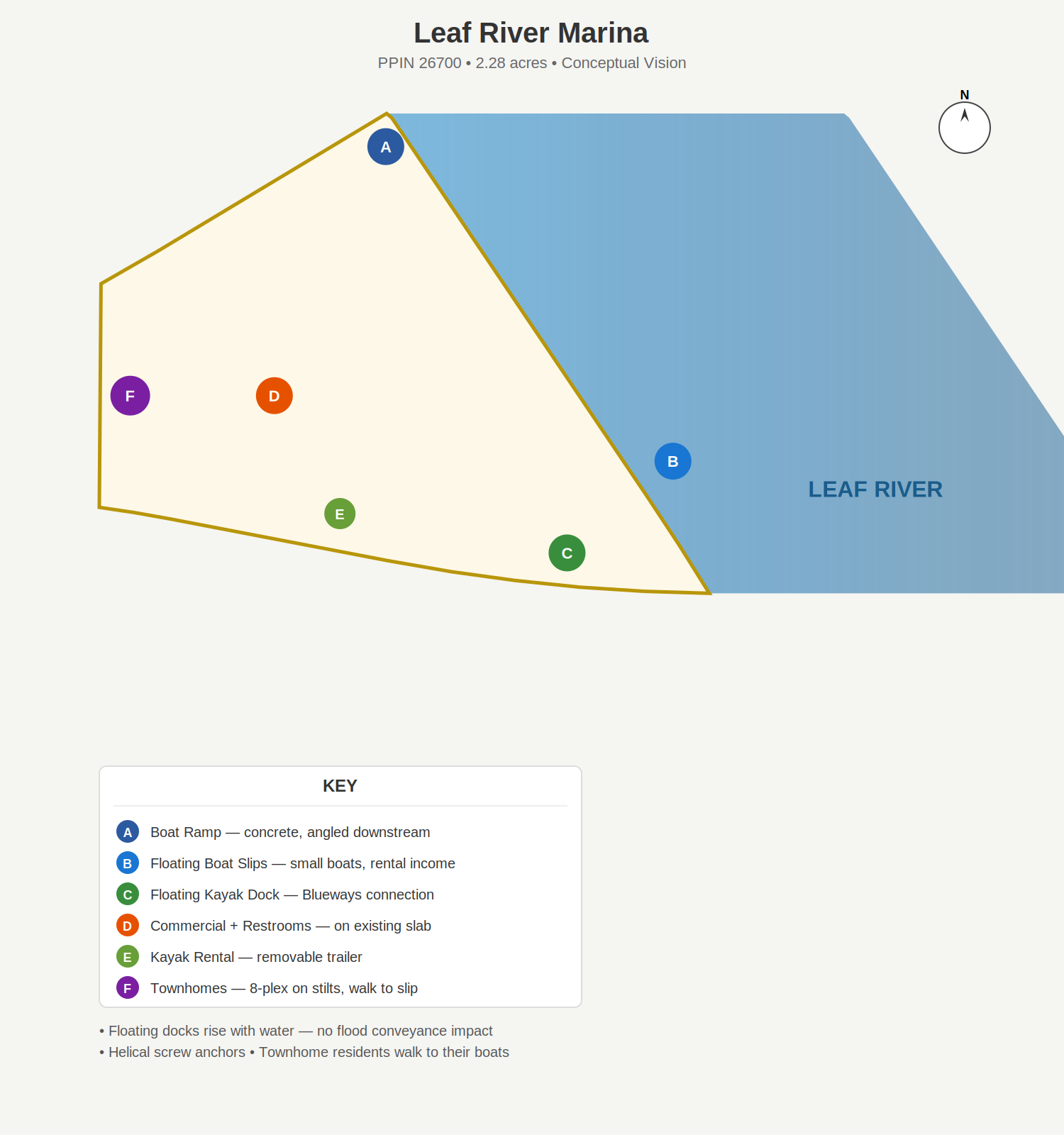
Conceptual layout — zones described below. Floating boat slips positioned SE along river.
Floating docks rise with water level during flood events. They do not obstruct flood conveyance — water passes underneath. The only fixed elements are helical screw anchors (minimal diameter, drilled into riverbed) and chain with tension cords that expand/contract with water level changes.
HEC-RAS models fixed structures as blocked obstructions. Floating structures sit on the water surface and move vertically with stage height. This distinction is material for No-Rise certification.
| Reference | Notes |
|---|---|
| Captain Rod's Marina (IL) | Chain O'Lakes — floats rise with flood, no-wake zones during high water |
| Pistakee Marina (IL) | 86 floating slips, "rise with water level creating safe docking during flooding" |
| Muscatine Marina (IA) | Mississippi River, 48 slips, "dates fluctuate based on flooding" |
| Parcel | PPIN 26700 — 2.28 acres |
| River frontage | Direct access along east boundary |
| Existing slabs | 36'×60' (good condition), 28'×28' |
| Blueways connection | Pinebelt Blueways paddling trail passes site |
| Zone | Use | Notes |
|---|---|---|
| A | Boat ramp | Concrete, 12-15% grade, angled downstream |
| B | Floating boat slips | SE along river, helical anchors, chain w/tension cords |
| C | Kayak/canoe dock | Floating, ADA transfer bench, separate from motor boats |
| D | Commercial + restrooms | On good slab — ~4,000 sf commercial, ~1,000 sf public restrooms |
| E | Kayak rental | Movable trailer (removed before flood events) |
| F | Townhomes | 8-plex on stilts, west edge — residents walk to boat slips |
Helical screw anchors are drilled into the riverbed with minimal obstruction footprint. Chain catenary with tension cords provides slack while maintaining stability — the system expands and contracts with changing water levels.
| Anchor type | Helical screw (eco-friendly, higher holding capacity than traditional) |
| Weight capacity | 600+ lbs at dock corners, more for exposed positions |
| Chain pattern | Crisscross for stability |
Reference: Dock Guide — Anchoring Systems
| Source | Rate | Notes |
|---|---|---|
| Big Eddy Marina (OR) | $495 / 2-month season | Columbia River, includes gated trailer storage |
| Regional small-boat marinas | $250-500 / month | Typical range for covered/uncovered slips |
Additional revenue: kayak rentals, commercial lease (restaurant/bait shop), public restroom maintenance agreement with local government.
| Floodway permit | Confirm floating docks qualify as non-obstructing under local ordinance |
| Commercial zoning | Verify marina/restaurant use permitted on north parcel |
| Blueways coordination | Any requirements for connecting to public trail system? |
| ADA compliance | Accessible gangway requirements for floating docks |
| Boat ramp permit | USACE Section 10 permit required for work in navigable waters? |
A public park changes the approval conversation — the city gets something, not just the developer. A 5-7 acre riverfront park supports the City's Pinebelt Blueways initiative and provides public river access. Park size and configuration depend on final development layout and any density negotiations.
| Kayak/canoe launch | Connection to Blueways paddling trail |
| Fishing piers | River access for anglers |
| Picnic pavilion | Covered area with tables |
| Walking trails | Riverfront paths |
| Cooking areas | Grills, prep surfaces |
Final amenities determined based on city input and development negotiations.
Hattiesburg is already investing in riverfront access through Pinebelt Blueways:
| Sims Road Boat Ramp | $1M+ project currently underway |
| MS Outdoor Stewardship Grant | $480,000 awarded for Sims Road improvements |
| Program Goal | Connected water trail system throughout Pinebelt region |
Resources: Mississippi Blueways GIS Map
| Park | Location | Features |
|---|---|---|
| River Park | Pascagoula, MS | 8.6 acres, 650-ft fishing pier, boat ramp, ADA kayak launch |
| May Day Park | Daphne, AL | Pier, kayak launch, boardwalk, covered gazebo |
| Clyde Fant Parkway | Shreveport, LA | Linear riverfront trail, boat launch, pavilion, picnic areas |
The park changes the approval equation. Instead of a developer requesting approvals, the conversation becomes a negotiation where both sides gain something:
| City receives | Public riverfront park aligned with existing Blueways investment |
| Development receives | Community support, potential density credit, political goodwill |
| City interest | Would Hattiesburg accept a park dedication? |
| Maintenance | City maintains, or HOA with city access easement? |
| Density credit | Does park dedication support higher density under PUD? |
| Blueways coordination | Requirements for official trail connection? |
Why this matters: The numbers have to work. If they don't, we find out now — not after capital is committed.
| Total revenue | $20,000,000 |
| Total development cost | ~$15,000,000 |
| Gross profit | ~$5,000,000 |
| Margin | ~25% |
| Sale price | $200,000/home |
| Build cost | $133,000/home |
| Infrastructure | $200,000 total (private drives) |
| Soft costs | ~$1,300,000 |
- Refine construction cost with local quotes
- Update based on city feedback on density
- Add financing costs when structure determined
Risk Level: Medium. Assumptions need verification.
Homes that can't be financed can't be sold — and an unsold development buries the developer. Standard elevated construction on piers qualifies for conventional mortgage products when properly documented.
New construction in Special Flood Hazard Areas (SFHA) requires an Elevation Certificate from a licensed engineer or surveyor. As of January 2025, FHA requires the lowest floor be at least 2 feet above Base Flood Elevation.
| Requirement | Standard |
|---|---|
| Elevation | Lowest floor 2+ ft above BFE (Jan 2025 rule) |
| Documentation | FEMA Elevation Certificate (Form 81-31) |
| Insurance | NFIP flood insurance required |
| CRS discount | Hattiesburg Class 7 = 15% premium reduction (effective April 2026) |
| Construction type | Site-built on piers eligible if properly elevated |
Source: FHA Flood Zone Requirements, Hattiesburg CRS Announcement
Mississippi Home Corporation administers multiple programs for first-time buyers.
| Program | Amount | Terms |
|---|---|---|
| Easy8 | $8,000 | 0% interest, deferred until sale/refi |
| Trusty10 | $10,000 | 2% interest, 15-year repayment |
| Smart6 | $6,000 | 0% interest, deferred |
| Home4All | Up to $25,000 | Grant, need-based, 5-year deed restriction |
| MCC | Tax credit | Up to 40% of mortgage interest as federal tax credit |
These programs combine with FHA (3.5% down), USDA (0% down for rural areas), and conventional loans.
Unlike condos, individual homes in a Planned Unit Development do not require separate FHA project approval. Each home can be financed independently with FHA, VA, USDA, or conventional loans.
PUD zoning details are in Section 4: Zoning & Entitlements.
Spec construction loans fund homes without pre-committed buyers. Pre-sold homes with buyer deposits reduce lender risk and may qualify for better terms.
| Factor | Typical Terms |
|---|---|
| Term | 12-18 months |
| Loan-to-Cost | Up to 85% LTC |
| Loan-to-Value | Up to 75% of completed value |
| Payments | Interest-only during construction |
| Unsold limit | Banks often cap unsold units at any time |
Source: Builder Finance Inc.
Sequential development differs from phased development. Rather than committing to large phases, homes are built incrementally as demand materializes.
| Principle | Application |
|---|---|
| Presales first | Reduce speculation with buyer deposits before construction |
| Infrastructure matching | Build only homes that existing utilities can serve |
| Avoid deep commitment | No large loans without corresponding income |
| Speed follows demand | Build faster only if market absorbs units |
| Completion priority | Finish each home before starting next to avoid incomplete inventory |
| Question | Status |
|---|---|
| City flood freeboard requirement? | Partially confirmed. Hattiesburg has "higher standards" (CRS Class 7). Exact freeboard unknown — call Planning 601-545-4599. |
| Which MHC programs apply? | Likely Smart6, Easy8, Trusty10 at $180K-$280K price point. USDA 0% down available in Forrest County. |
| Unsold-unit limit? | Likely 2-4 units for first-time developers. Sequential approach aligns with lender preferences. |
| Presales before loan release? | 0-2 depending on loan type. Presale deposit + buyer pre-approval significantly improves terms. |
Why this matters: Flood zone homes require flood insurance. If insurance is unaffordable, the homes don't sell.
| Flood zone | Zone AE and Floodway |
| Elevation strategy | 10 ft above grade on piers |
| Insurance expectation | Lower premiums due to elevation |
- Get flood insurance quotes for elevated structure
- Confirm elevation certificate requirements
- Verify NFIP participation status for Hattiesburg
Risk Level: Medium. Not yet started.
Why this matters: Every project has risks. Identifying them early allows for mitigation rather than surprise.
| Risk | Mitigation |
|---|---|
| City denies rezoning | Pre-application meeting, community support |
| No-Rise fails | Relocate clusters to Zone AE |
| Construction costs higher | Verify with local quotes before committing |
| Sales slower than projected | Phased approach limits exposure |
| Utility infrastructure missing | Verify before city meeting |
| Standard contingency | 5-10% of hard costs |
| Estimated amount | $500,000 - $1,000,000 |
Risk Level: Medium. Key risks identified.
Why this matters: Building in phases limits financial exposure and allows course correction based on market response.
| Phase | Location | Why |
|---|---|---|
| 1 | Cluster E (south) | Zone AE — no No-Rise required |
| 2 | Cluster D | Zone AE — no No-Rise required |
| 3 | Cluster C | Floodway — requires No-Rise |
| 4 | Cluster B | Floodway |
| 5 | Cluster A (north) | Floodway — near amenity hub |
| 6 | North development | Combined plan addition |
- Start with easiest approvals (Zone AE)
- Test market before committing to floodway
- Generate revenue before completing full buildout
- Presales in early phases fund later phases
Risk Level: Complete. Strategy defined.
Why this matters: The wrong contractor can destroy a project. Selection criteria and contract structure protect the investment.
| Model | Pros | Cons |
|---|---|---|
| General Contractor (GC) | Single point of responsibility | Markup on everything |
| Construction Manager (CM) | More control, transparent costs | More owner involvement |
| Owner-Builder | Maximum savings | Maximum risk and effort |
- Licensed and insured in Mississippi
- Experience with elevated construction
- References from similar projects
- Financial stability to complete work
- Fixed price or guaranteed maximum
- Performance bond (if required)
- Draw schedule tied to completion milestones
- Warranty requirements
Risk Level: Medium. Framework complete, contractor not yet selected.
Why this matters: Permits are the gate to construction. Understanding the approval path prevents surprises and delays.
| Permit | Authority |
|---|---|
| Rezoning / PUD | Hattiesburg Planning |
| Floodplain Development | Floodplain Administrator |
| No-Rise Certification | FEMA (via local admin) |
| Building Permit | City of Hattiesburg |
| Driveway Permit | City or County |
| SWPPP/NOI | MDEQ (if >1 acre disturbed) |
| Pre-application meeting | Schedule within 2-4 weeks |
| Rezoning approval | 2-4 months |
| No-Rise certification | 1-2 months |
| Building permit | 2-4 weeks after approval |
Risk Level: High. Not yet started.
Why this matters: Floodway development is politically sensitive. City approval requires more than good engineering — it requires support.
| FEMA risk | Violations can suspend community from NFIP |
| Consequence | No flood insurance for any property in city |
| Result | Planning staff defaults to "no" on floodway projects |
- Workforce housing at price points that don't exist in market
- Conservation of ~18 acres as recreation/open space
- Potential public park with river access
- Quality construction, not mobile homes
- Energy-efficient, modern design
- Employer outreach (hospital, university, Camp Shelby)
- Realtor validation of demand
- Community presentation via website
- Pre-application meeting to gauge city interest
Risk Level: Medium. Strategy defined, execution pending.
Why this matters: How money comes back determines which investors fit. Different exits suit different goals.
| Strategy | Description | Timeline |
|---|---|---|
| Sell Completed Homes | Build, finish, sell to end buyers | 6-12 months per phase |
| Sell Lots with Plans | Entitled lots to builders | Faster, lower profit |
| Build-to-Rent | Hold as rental portfolio | Ongoing income, no exit |
| Hybrid | Sell some, rent some | Balances cash flow and profit |
If landowners want a partner before approval, they can bring in a builder-developer. Pre-entitlement partners expect significant discount for the risk they're taking.
After approval, entitled land is worth more. Landowners keep more upside by completing the entitlement process before seeking partners.
Risk Level: Low. Multiple viable options.
Why this matters: We don't know what we don't know. The approval process surfaces issues no checklist can predict.
People are unpredictable. City staff, elected officials, neighbors, and stakeholders will have ideas, concerns, and requests that we can't anticipate today.
This isn't a rigid plan — it's a framework. When new issues arise, we listen, adapt, and find solutions that work for everyone. The goal is approval, not winning arguments.
- Park design modifications (wildflowers, fishing pier, trail connections)
- Density adjustments if justified
- Phasing changes for infrastructure timing
- Community amenities we haven't thought of yet
- Project viability — it still has to work financially
- Safety and engineering standards
- Honest dealing
The Mindset: If the city or neighbors have a good idea, we incorporate it. That's how projects get approved.
Risk Level: Ongoing. Always.
Why this matters: Direct material procurement eliminates contractor markup and ensures quality control. This is how we hit $133/SF when others can't.
Traditional vs. Our Approach
| Traditional (GC Buys) | Our Approach |
|---|---|
| GC marks up materials 15-25% | Direct vendor relationships |
| No visibility into substitutions | Specifications locked at component level |
| Quality varies by GC preference | Quality controlled by specification |
| Start over every project | System improves over time |
Example: Lighting
| Traditional | 120V fixtures, standard electrical |
| Our approach | 24V LED system — lower material cost, lower install cost, lower energy use |
Savings Impact
| GC markup avoided | ~15-20% on materials |
| Materials cost per home | ~$80,000 |
| Savings per home | $12,000 - $16,000 |
| Savings (100 homes) | $1,200,000 - $1,600,000 |
Timing
After city approval. No point sourcing materials if the project doesn't get approved. Cost is paid from the development fee during construction phase.
Related: See Section 9: Cost Analysis System for the software platform.
A project like this requires flood engineering, site planning, financing, city approvals, and construction coordination. Each of those is typically a separate consultant working to their own priorities and billing their own hours.
What we bring is integration — figuring out what needs to be done, then giving each consultant a specific scope instead of an open-ended assignment. The civil engineer gets clear direction. The PE certifying the No-Rise study gets a preliminary model already built. The architect gets specifications, not a blank page. That focus reduces both cost and time.
We also have a procurement methodology that can reduce construction costs. We won't put a specific number on that until we know what's actually being built, but the approach is proven: independent bids on each major assembly, direct material procurement, and a wider contractor pool because we're not burdening them with material costs. The savings typically run 15-20% on total build cost.
The fee structure is straightforward. Predevelopment advances are paid as work progresses and credited against the final development fee. If the project doesn't proceed, we've been paid fairly for our time. If it does proceed, the advances were just early draws on what we earned.
The goal is specific: get this property developed, built, and producing income. That's not open-ended. The predevelopment checklist on this website defines the scope — every item is visible, and the work required to complete each one is understood.
Development fee and payment terms are discussed directly with project owners.
Project owners: View fee structure details (login required)